Toggle navigation
LMEC Home
Exhibitions
Georeferencing
Tools for Teachers
Collections
My Favorites
Sign Up / Log In
Search
Search the map portal
Map Collection
Map Collection
Map Sets
Search
Search
Search for
Search In
All Fields
Creator
Title
Subject
Place
Search All Digital Collections
Advanced Search
30 Results
My Search
Start Over
"G1015 .A85 1783"
Remove constraint "G1015 .A85 1783"
Filter your Search
Place
Europe
18
Asia
5
Africa
3
Balkan Peninsula
2
Central Europe
2
Germany
2
Italy
2
Turkey
2
more
Place
»
Topic
Balkan Peninsula--Maps--Early works to 1800
2
Europe, Central--Maps--Early works to 1800
2
Italy--Maps--Early works to 1800
2
Africa--Maps
1
America--Maps
1
Asia--Maps
1
Belgium--Early works to 1800--Maps
1
Biscay, Bay of (France and Spain)--Navigation--Maps--Early works to 1800
1
more
Topic
»
Date
Date range begin
–
Date range end
Current results range from
1743
to
1783
View distribution
Creator
Faden, William, 1749-1836
10
Lattré, Jean
7
Bonne, Rigobert, 1727-1794
4
Kitchin, Thomas, 1718-1784
4
Sayer, Robert, 1725-1794
4
Anville, Jean Baptiste Bourguignon d', 1697-1782
3
Delarochette, L. (Louis), 1731-1802
3
Janvier, Jean Denis
3
more
Creator
»
Format
Maps/Atlases
30
Georeferenced
Yes
2
No
28
Collection
Norman B. Leventhal Map & Education Center Collection
30
Maritime Charts and Atlases
1
Available to use
No known restrictions
30
Search Constraints
Sort by relevance
relevance
title
date (asc)
date (desc)
Number of results to display per page
20 per page
10
per page
20
per page
50
per page
100
per page
View results as:
grid view
map view
Search Results
1.
L'Afrique divisée en ses principaux états
2.
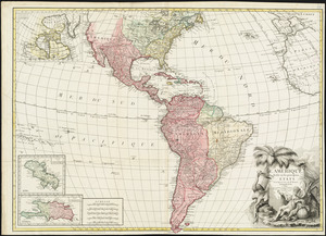
L'Amérique divisée en ses principaux états
3.
Amérique méridionale : publiée sous les auspices de Monseigneur le Duc d'Orleans prémier prince du Sang
4.
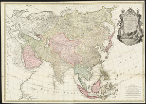
Carte de l'Asie divisée en ses principaux etats
5.
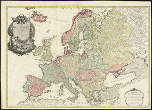
Carte de l'Europe divisée en ses principaux états
6.
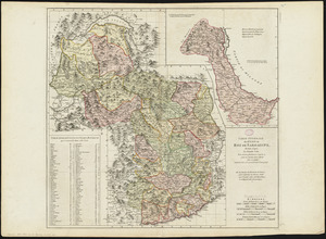
Carte générale des états du Roi de Sardaigne, reduite d'après la grande carte : pour trouver facilement ce qu'on a envie de...
7.
The Catholic Netherlands, divided into their several provinces with the roads
8.
A chart of the British Channel and the Bay of Biscay, with a part of the North Sea, and the entrance of St. George's Channel
9.
A chart of the world upon Mercator's projection : describing the tracks of Capt. Cook in the year 1768, 69, 70, 71, and in...
10.
Constantinople, or Stambol
11.
The Dutch colony of the Cape of Good Hope
12.
Egypte nommée dans le pays Missir
13.
La France divisée par généralités
14.
Hindoostan
15.
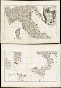
L'Italie : publiée sous les auspices de Monseigneur le Duc d'Orleans, Prémier Prince du Sang
16.
The kingdom of Poland and Great Dutchy of Lithuania with all their divisions
17.
The kingdoms of Spain and Portugal, divided into their great provinces
18.
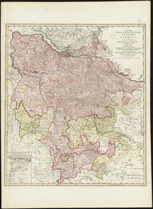
Map of the Empire of Germany : including all the states comprehended under that name : with the Kingdom of Prussia, &c
19.
A map of the King of Great Britains dominions in Germany, or, the Electorate of Brunswick-Luneburg, with its dependencies :...
20.
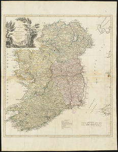
A new map of Ireland divided into provinces, counties, &c
‹ Prev
Next ›
1
2