Toggle navigation
LMEC Home
Exhibitions
Georeferencing
Tools for Teachers
Collections
My Favorites
Sign Up / Log In
Search
Search the map portal
Map Collection
Map Collection
Map Sets
Search
Search
Search for
Search In
All Fields
Creator
Title
Subject
Place
Search All Digital Collections
Advanced Search
66 Results
My Search
Start Over
1847
Remove constraint 1847
Filter your Search
Place
North and Central America
40
United States
23
Boston Harbor
6
Europe
6
Boston
5
Ecuador
5
Suffolk (county)
5
Mexico
4
more
Place
»
Topic
Boston Harbor (Mass.)--Maps
6
Mexican War, 1846-1848--Campaigns--Maps
3
Boston (Mass.)--Maps
2
Dramatists, English--Homes and haunts--England--Stratford-upon-Avon
2
Germany--Maps
2
Massachusetts--Maps
2
Mexico, Valley of (Mexico)--Maps
2
Nautical charts--Massachusetts--Boston Harbor
2
more
Topic
»
Date
Date range begin
–
Date range end
Current results range from
1815
to
1929
View distribution
Creator
United States. Hydrographic Office
13
United States Coast Survey
4
Franke, M. (Max)
3
Klakring, A. (Alfred)
3
Latimer, J. S. (Joseph S.)
3
Ruebsam, E. A. (E. August)
3
Bruff, Joseph Goldsborough, 1804-1889
2
J.H. Bufford's Lith
2
more
Creator
»
Format
Maps/Atlases
63
Manuscripts
4
Prints
3
Georeferenced
Yes
7
No
59
Collection
Norman B. Leventhal Map Center Collection
61
Boston and New England Maps
18
Maritime Charts and Atlases
18
Urban Maps
10
Mapping Boston Collection
4
Lucius Beebe Memorial Library Historic Maps
1
MacLean Collection Map Library
1
Robert E. Diefenbach Map Collection at Phillips Academy
1
more
Collection
»
Available to use
No known restrictions
60
Creative Commons license
4
Search Constraints
Sort by relevance
relevance
title
date (asc)
date (desc)
Number of results to display per page
20 per page
10
per page
20
per page
50
per page
100
per page
View results as:
grid view
map view
Search Results
1.
Battle of Cerro Gordo, April 17th & 18th 1847
2.
Extract from the plan of the coast survey of Boston Harbor, 1847
3.
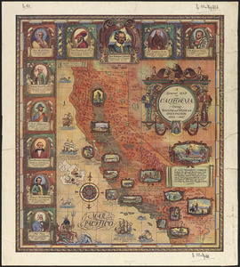
A general map of California during Spanish and Mexican occupation, 1542-1847
4.
West Indies, Haïti or St. Domingo, Gonaïves Bay : from a French survey, 1847
5.
Plan of an estate in High St. to be sold at auction Sat. May 1st 1847 at 12 o'clock on the premises by Whitwell, Seaver & Co....
6.
Dominion of Canada, Gulf of Saint Lawrence, Port Hood (Cape Breton Island) : from British surveys in 1847 & 1873
7.
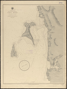
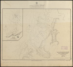
Dominion of Canada, New Brunswick, L'Etang Harbor (Bay of Fundy) : from a British survey in 1847
8.
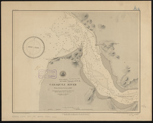
South America, Ecuador, Caraquez River : from a British survey in 1847
9.
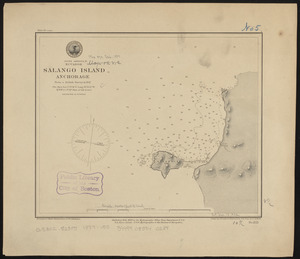
South America, Ecuador, Salango Island anchorage : from a British survey in 1847
10.
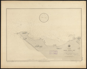
South America, Ecuador, Santa Eléna Bay : from a British survey in 1847
11.
Siege of Vera Cruz, by the U.S. troops under Major General Scott, in March 1847, from surveys made by Major Turnbull, Captains...
12.
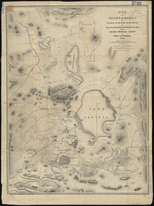
Map of the Valley of Mexico with a plan of the defences of the capital and the line of operations of the United States Army...
13.
Approaches to Cohasset Harbor Mass. : topography surveyed in 1847 ; hydrography surveyed in 1846-'56
14.
West Indies, west coast of Haiti, Port au Prince : from a French survey in 1847 corrected for the latest information, 1886
15.
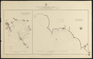
North America, west coast, ports on the west coast of Lower California : from British surveys in 1847, with additions by Comdr....
16.
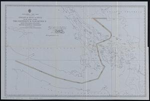
North America--west coast, Strait of Juan de Fuca and the channels between the continent & Vancouver Id. showing the boundary...
17.
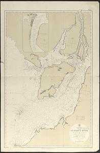
South America, west coast, Ecuador, Guayaquil River : from a British survey in 1847, corrected to 1876 ; republication of Brit....
18.
South America, west coast, harbors on the coast of Ecuador : from British surveys in 1837 and 1847 ; republication of Brit....
19.
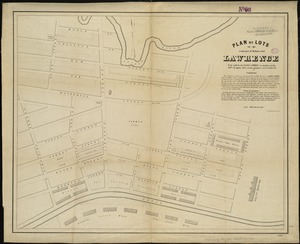
Plan of lots in that part of Methuen called Lawrence : to be sold by the Essex Company at auction on the 28th of April, 1847,...
20.
Map of central portion of the town of Yonkers : showing all buildings and other improvements as they stood in the summer of...
‹ Prev
Next ›
1
2
3
4