Toggle navigation
LMEC Home
Exhibitions
Georeferencing
Tools for Teachers
Collections
My Favorites
Sign Up / Log In
Search
Search the map portal
Map Collection
Map Collection
Map Sets
Search
Search
Search for
Search In
All Fields
Creator
Title
Subject
Place
Search All Digital Collections
Advanced Search
76 Results
My Search
Start Over
1803
Remove constraint 1803
Filter your Search
Place
North and Central America
51
United States
47
Europe
7
New York
7
North America
6
Ohio
4
Boston
3
Essex (county)
3
more
Place
»
Topic
United States--Maps
7
Georgia--Maps
3
Manhattan (New York, N.Y.)--Maps
3
New York (N.Y.)--Administrative and political divisions--Maps
3
North America--Maps--Early works to 1800
3
Boston (Mass.)--Aerial views
2
Kentucky--Maps
2
Maryland--Maps
2
more
Topic
»
Date
Date range begin
–
Date range end
Current results range from
1753
to
1932
View distribution
Creator
Barker, W. (William), active 1795-1803
31
Carey, Mathew, 1760-1839
29
Burr, David H., 1803-1875
7
Lewis, Samuel, 1753 or 4-1822
5
Arrowsmith, Aaron, 1750-1823
3
Dorman, Moses, 1803-1877
3
Brion de la Tour, Louis, fl. 1756-1803
2
Carleton, Osgood, 1742-1816
2
more
Creator
»
Format
Maps/Atlases
76
Georeferenced
Yes
8
No
68
Collection
Norman B. Leventhal Map Center Collection
57
American Revolutionary War-Era Maps
17
Boston and New England Maps
10
Urban Maps
8
New York Public Library Collection
5
American Antiquarian Society Collection
3
Richard H. Brown Revolutionary War Map Collection at Mount Vernon
3
Town plans, 1830
3
more
Collection
»
Available to use
No known restrictions
60
Creative Commons license
9
Search Constraints
Sort by relevance
relevance
title
date (asc)
date (desc)
Number of results to display per page
20 per page
10
per page
20
per page
50
per page
100
per page
View results as:
grid view
map view
Search Results
1.
American explorations in the West, 1803-1852
2.
Carte des pays connus sous le nom de Canada, : dans laquelle sont distinguées les possessions françoises, et angl?
3.
A map of the United States of North America : drawn from a number of critical researches
4.
Carte du Mexique et des pays limitrophes situés au nord et à l'est : dressée d'après la grande carte de la Nouvelle Espagne...
5.
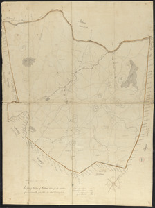
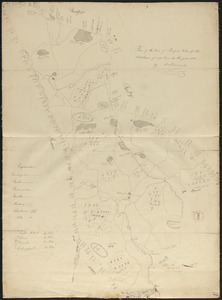
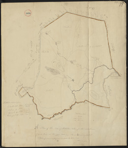
Plan of Andover made by Moses Dorman, Jr., dated 1830
6.
Plan of Boxford made by Moses Dorman, Jr. dated 1830
7.
Plan of Middleton made by Moses Dorman, Jr., dated 1830
8.
City of New-York
9.
Map, boundary, Michigan and Ohio
10.
Map exhibiting the country between Lakes Michigan and Erie, and the contested boundary lines
11.
Map of Maine, New Hampshire, Vermont, Massachusetts, Rhode Island, and Connecticut : exhibiting the post offices, post roads,...
12.
Map of the United States exhibiting the several collection districts
13.
State of New York
14.
Vereinigte Staaten von Nord-America
15.
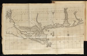
Map of the Lower Mississippi River
16.
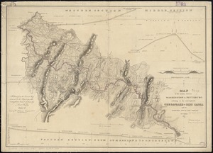
Map of the country between Washington & Pittsburg refering to the contemplated Chesapeake & Ohio Canal and its general route...
17.
A new and accurate map of the English empire in North America : representing their rightful claim as confirm'd by charters, and...
18.
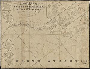
A new chart of the coast of America from Boston to Savannah with plans on an enlarged scale, of the principal harbours :...
19.
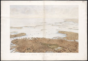
Bird's eye view of Boston
20.
The world, on Mercator's projection : showing the different routes to California, and distance by each; routes of different...
‹ Prev
Next ›
1
2
3
4