Toggle navigation
LMEC Home
Exhibitions
Georeferencing
Tools for Teachers
Collections
My Favorites
Sign Up / Log In
Search
Search the map portal
Map Collection
Map Collection
Map Sets
Search
Search
Search for
Search In
All Fields
Creator
Title
Subject
Place
Search All Digital Collections
Advanced Search
77 Results
My Search
Start Over
Date
1740
to
1744
Remove constraint Date: <span class='from'>1740</span> to <span class='to'>1744</span>
Filter your Search
Place
North and Central America
45
United States
19
Canada
9
North America
9
New York
7
South America
7
Europe
6
America
4
more
Place
»
Topic
North America--Maps--Early works to 1800
5
Anglo-Spanish War, 1739-1748--Maps, Manuscript--Early works to 1800
3
Antigua--Maps--Early works to 1800
3
Coasts--Florida--Maps, Manuscript--Early works to 1800
3
Florida--Maps, Manuscript--Early works to 1800
3
Saint Augustine (Fla.)--Maps, Manuscript--Early works to 1800
3
Vernon, Edward, 1684-1757
3
Western Hemisphere--Maps--Early works to 1800
3
more
Topic
»
Date
1740
to
1744
[remove]
77
Date range begin
–
Date range end
Current results range from
1699
to
1800
1740
to
1740
47
1741
to
1741
34
1742
to
1742
30
1743
to
1743
35
1744
to
1744
42
Creator
Bellin, Jacques Nicolas, 1703-1772
8
Buache, Philippe, 1700-1773
6
George, III, King of Great Britain, 1738-1820
6
George, IV, King of Great Britain, 1762-1830
6
Royal United Services Institute for Defence and Security Studies
5
Amherst, Jeffery Amherst, Baron, 1717-1797
3
Nolin, Jean Baptiste, 1686-1762
3
Seutter, Matthaeus, 1678-1756
3
more
Creator
»
Format
Maps/Atlases
76
Manuscripts
8
Prints
1
Georeferenced
Yes
5
No
72
Collection
American Revolutionary War-Era Maps
46
Norman B. Leventhal Map Center Collection
34
William L. Clements Library Collection
16
British Library Collection
14
Richard H. Brown Revolutionary War Map Collection at Mount Vernon
6
Boston and New England Maps
5
MacLean Collection Map Library
3
Urban Maps
3
more
Collection
»
Available to use
No known restrictions
36
Creative Commons license
21
Search Constraints
Sort by relevance
relevance
title
date (asc)
date (desc)
Number of results to display per page
10 per page
10
per page
20
per page
50
per page
100
per page
View results as:
grid view
map view
Search Results
1.
[A manuscript map of Isle Royalle]
2.
[Acadie, Isle Saint Jean and part of Isle Royale with the Baye Francoise]
3.
An accurate map of the West Indies : exhibiting not only all the islands possess'd by the English, French, Spaniards & Dutch...
4.
[Amerique septentrionale]
5.
Carte de la Louisiane cours du Mississipi et pais voisins : dediée à M. le Comte de Maurepas, ministre et secretaire d'etat...
6.
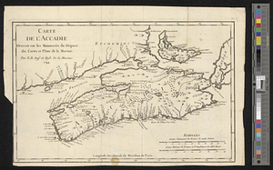
Carte de l'Accadie : dressée sur les manuscrits de Dépot des Cartes et Plans de la Marine
7.
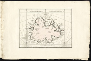
Carte de l'isle d'Antigoa une de Isles Antilles
8.
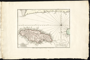
Carte de l'isle de la Jamaique
9.
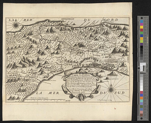
Carte de l'isthme de Panama depuis Panama jusques à la rivière de Nata du coté du sud, et depuis Porto Bello, jusques à la...
10.
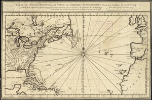
Carte de l'ocean occidental et partie de l'Amerique septentrionale : dressée pour l'intelligence du Journal du voyage que le...
‹ Prev
Next ›
1
2
3
4
5
…
7
8
![[A manuscript map of Isle Royalle]](https://bpldcassets.blob.core.windows.net/derivatives/images/commonwealth:hx11z507d/image_thumbnail_300.jpg)
![[Acadie, Isle Saint Jean and part of Isle Royale with the Baye Francoise]](https://bpldcassets.blob.core.windows.net/derivatives/images/commonwealth:hx11z490f/image_thumbnail_300.jpg)

![[Amerique septentrionale]](https://bpldcassets.blob.core.windows.net/derivatives/images/commonwealth:8336h2955/image_thumbnail_300.jpg)