Toggle navigation
LMEC Home
Exhibitions
Georeferencing
Tools for Teachers
Collections
My Favorites
Sign Up / Log In
Search
Search the map portal
Map Collection
Map Collection
Map Sets
Search
Search
Search for
Search In
All Fields
Creator
Title
Subject
Place
Search All Digital Collections
Advanced Search
138 Results
My Search
Start Over
Date
1849
Remove constraint Date: <span class='single'>1849</span>
Filter your Search
Place
North and Central America
59
United States
48
Oceania
32
Europe
25
Massachusetts
19
French Polynesia
9
New England
9
Fiji
8
more
Place
»
Topic
United States Exploring Expedition (1838-1842)
16
New England--Maps
8
Railroads--New England--Maps
7
China--Maps
6
Railroads--New York (State)--Maps
6
Tuamotu Archipelago (French Polynesia)--Maps
6
Massachusetts--Maps
5
New York (State)--Maps
5
more
Topic
»
Date
1849
[remove]
138
Date range begin
–
Date range end
Current results range from
1770
to
1990
1849
to
1849
138
Creator
United States Exploring Expedition (1838-1842)
34
Wilkes, Charles, 1798-1877
31
Sherman & Smith
19
J. & C. Walker (Firm)
8
Great Britain. Hydrographic Office
7
Vidal, A. T. E. (Alexander Thomas Emeric), 1792-1863
7
Boynton, George W., -1884
3
Collinson, Richard, Sir, 1811-1883
3
more
Creator
»
Format
Maps/Atlases
138
Manuscripts
13
Georeferenced
Yes
10
No
128
Collection
Norman B. Leventhal Map & Education Center Collection
120
Maritime Charts and Atlases
47
Boston and New England Maps
22
Urban Maps
18
American Revolutionary War-Era Maps
12
Library of Congress Collection
5
MacLean Collection Map Library
4
Newberry Library Collection
2
more
Collection
»
Available to use
No known restrictions
123
Creative Commons license
6
Search Constraints
Sort by relevance
relevance
title
date (asc)
date (desc)
Number of results to display per page
20 per page
10
per page
20
per page
50
per page
100
per page
View results as:
grid view
map view
Search Results
121.
Seven miles around Jerusalem : from original surveys and observations
122.
[Sketch of the region of the island of Cape Breton, between the parallels of forty-five and forty-eight degrees of latitude]
123.
St. Pablo, Paumotu Group ; Nukutipipi or Margaret Island, Paumotu Group ; Heretua or Archangel of Quiros, Paumotu Group ; Teku...
124.
Swains Island ; Jarvis' Island ; Birnies Island, Phœnix Group ; Enderbury' Island, Phœnix Group - Hull's Island, Phœnix Group ;...
125.
Taiara or King's Island ; Henuake, Honden or Dog Id. ; Penrhyns Island ; Two groups
126.
Taputeouea or Drummond's Island, Kingsmill Group ; Peacock's anchorage at Drummond's Island, Kingsmill Group
127.
This map of Kentucke
128.
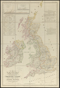
To her most excellent majesty Queen Victoria this hydrographical map of the British Isles, exhibiting the geographical...
129.
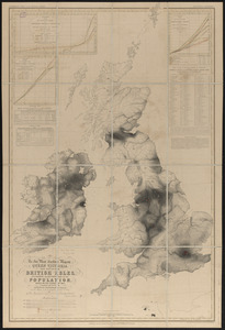
To her most excellent majesty Queen Victoria this map of the British Isles, elucidating the distribution of the population,...
130.
To the Honble. the Court of Directors of the United East India Company, this chart, intended as an accompaniment to the book of...
131.
Typo de la carta cosmographica de Gaspar Vopellio Medeburgense
132.
The United States : the relative position of the Oregon & Texas and California
133.
Vereinigte Staaten Von Nordamerika
134.
West Indien und Mittel America
135.
Western route, from Boston to Michigan, Ohio and Indiana ; Southern route, from Boston to Wilmington and Red Clay ; S. Western...
136.
Whippy Harbour, south side of Viti Levu ; Suva Harbour, south side of Viti Levu ; Granby Harbour, south side of Viti Levu ;...
137.
Willard's new map of the Hudson River
138.
Yeojido
‹ Prev
Next ›
1
2
3
4
5
6
7

![[Sketch of the region of the island of Cape Breton, between the parallels of forty-five and forty-eight degrees of latitude]](https://bpldcassets.blob.core.windows.net/derivatives/images/commonwealth:4m90fh38k/image_thumbnail_300.jpg)