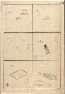
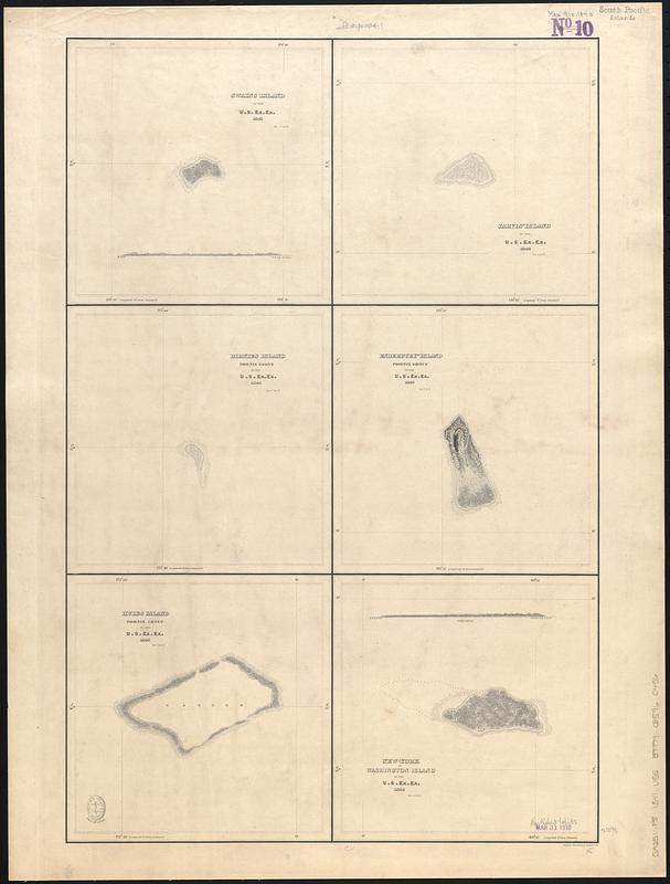
Swains Island ; Jarvis' Island ; Birnies Island, Phœnix Group ; Enderbury' Island, Phœnix Group - Hull's Island, Phœnix Group ; New-York or Washington Island
Item Information
- Title:
- Swains Island ; Jarvis' Island ; Birnies Island, Phœnix Group ; Enderbury' Island, Phœnix Group - Hull's Island, Phœnix Group ; New-York or Washington Island
- Contributor:
- Wilkes, Charles, 1798-1877
- Cartographer:
- United States Exploring Expedition (1838-1842)
- Name on Item:
-
by the U.S. Ex. Ex. 1840 ; eng. by Sherman & Smith
- Date:
-
[1840–1849]
- Format:
-
Maps/Atlases
- Genre:
-
Nautical charts
- Location:
-
Boston Public Library
Norman B. Leventhal Map & Education Center - Collection (local):
-
Norman B. Leventhal Map & Education Center Collection
- Subjects:
-
Swains Island (American Samoa)--Maps
Jarvis Island (Line Islands)--Maps
Birnie Island (Kiribati)--Maps
Enderbury Atoll (Kiribati)--Maps
Orona Atoll (Kiribati)--Maps
Washington Island (Kiribati)--Maps
Nautical charts--American Samoa--Swains Island
Nautical charts--Line Islands--Jarvis Island
Nautical charts--Kiribati--Birnie Island
Nautical charts--Kiribati--Enderbury Atoll
Nautical charts--Kiribati--Orona Atoll
Nautical charts--Kiribati--Washington Island
- Places:
-
American Samoa (territory)Swains Island (atoll)
Jarvis Island (territory)
KiribatiBirnie Atoll
KiribatiEnderbury Atoll
KiribatiOrona (atoll)
KiribatiTeraina (island)
- Extent:
- 6 maps on 1 sheet ; 61 x 40 cm
- Terms of Use:
-
No known copyright restrictions.
No known restrictions on use.
- Scale:
-
Scales differ
- Language:
-
English
- Table of Contents:
-
Swains Island
Jarvis' Island
Birnies Island
Enderbury' Island
Hull's Island
New-York or Washington Island
- Notes:
-
Relief and depths shown pictorially.
Published in Narrative of the United States Exploring Expedition : during the years 1838, 1839, 1840, 1841, 1842.
- Notes (date):
-
This date is inferred.
- Identifier:
-
06_01_017533
- Call #:
-
G9251.P5 1841 .U55
- Barcode:
-
39999085960456