Toggle navigation
LMEC Home
Exhibitions
Georeferencing
Tools for Teachers
Collections
My Favorites
Sign Up / Log In
Search
Search the map portal
Map Collection
Map Collection
Map Sets
Search
Search
Search for
Search In
All Fields
Creator
Title
Subject
Place
Search All Digital Collections
Advanced Search
124 Results
My Search
Start Over
Date
1805
to
1809
Remove constraint Date: <span class='from'>1805</span> to <span class='to'>1809</span>
Filter your Search
Place
North and Central America
86
United States
67
Massachusetts
19
Europe
15
Boston
12
Suffolk (county)
12
Canada
6
New York
5
more
Place
»
Topic
Boston (Mass.)--Maps
9
United States--Maps
6
China--Maps
4
Korea--Maps
4
Manuscript maps
4
New Jersey--Maps
4
Canada--Maps
3
Massachusetts--Maps
3
more
Topic
»
Date
1805
to
1809
[remove]
124
Date range begin
–
Date range end
Current results range from
1760
to
1990
1805
to
1805
50
1806
to
1806
80
1807
to
1807
64
1808
to
1808
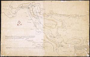
58
1809
to
1809
57
Creator
Carey, Mathew, 1760-1839
21
Barker, W. (William), active 1795-1803
13
Neele, Samuel John, 1758-1824
5
Doolittle, Amos, 1754-1832
4
Bulfinch, Charles, 1763-1844
3
Carleton, Osgood, 1742-1816
3
Lewis, Samuel, 1753 or 4-1822
3
Arrowsmith, Aaron, 1750-1823
2
more
Creator
»
Format
Maps/Atlases
124
Manuscripts
25
Georeferenced
Yes
20
No
104
Collection
Norman B. Leventhal Map & Education Center Collection
87
American Revolutionary War-Era Maps
30
Boston and New England Maps
24
Urban Maps
12
Library of Congress Collection
9
MacLean Collection Map Library
6
Maritime Charts and Atlases
5
New York Public Library Collection
5
more
Collection
»
Available to use
No known restrictions
88
Creative Commons license
18
Search Constraints
Sort by relevance
relevance
title
date (asc)
date (desc)
Number of results to display per page
20 per page
10
per page
20
per page
50
per page
100
per page
View results as:
grid view
map view
Search Results
101.
Plat of the ancient possessions of the upper prairie confirmed by the governors, their continuation from the Elm road to the...
102.
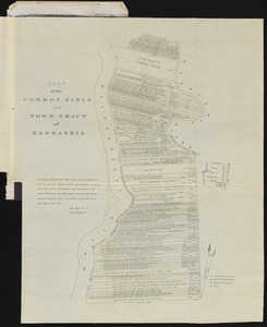
Plat of the common field and town tract of Kaskaskia
103.
Province of Maine
104.
Rhode Island
105.
The siege of Colberg, from 3d. to 31st. October, 1758
106.
Sketch of a route from Yorktown on Lake Ontario to Penatangasheen on Lake Huron - Upper Canada
107.
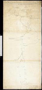
[Sketch of the region of the island of Cape Breton, between the parallels of forty-five and forty-eight degrees of latitude]
108.
Sketch of the Straits of St. Mary between Lake Huron and Lake Superior laid down from bearings of the principal points, and...
109.
South America : reduced from the sheet map
110.
South Carolina
111.
The state of New Hampshire
112.
Tennassee : lately the S. Wn. Territory
113.
This map of Kentucke
114.
This plan of the City of New York (within the palisades which were erected in the year 1743) was made for the purpose of...
115.
Typo de la carta cosmographica de Gaspar Vopellio Medeburgense
116.
The United States of America
117.
United States of America
118.
United States of America
119.
Die Vereinigten Staaten von Nord-America : nach den sichersten Bestimmungen, neuesten Nachrichten und Charten, in der...
120.
Vermont from actual survey
‹ Prev
Next ›
1
2
3
4
5
6
7


![[Sketch of the region of the island of Cape Breton, between the parallels of forty-five and forty-eight degrees of latitude]](https://bpldcassets.blob.core.windows.net/derivatives/images/commonwealth:4m90fh38k/image_thumbnail_300.jpg)