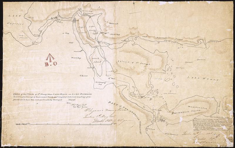
Sketch of the Straits of St. Mary between Lake Huron and Lake Superior laid down from bearings of the principal points, and computed distances, excepting a few places which have been more particularly surveyed, July 1796
This map is also available in American Revolutionary Geographies Online (ARGO), a collections portal especially built for material relating to the American Revolutionary War Era. Visit ARGO to learn more about this item and explore the historical geography of North America in the late eighteenth century.
Item Information
- Title:
- Sketch of the Straits of St. Mary between Lake Huron and Lake Superior laid down from bearings of the principal points, and computed distances, excepting a few places which have been more particularly surveyed, July 1796
- Cartographer:
- Bryce, Alexander
- Cartographer:
- Duberger, Jean-Baptiste, 1767-1821
- Name on Item:
-
(signed) Alex. Bryce, Lieut. Corps Royal Engineers
- Date:
-
1796–1816
- Format:
-
Maps/Atlases
- Genre:
-
Manuscript maps
- Location:
- Library and Archives Canada
- Collection (local):
-
Library and Archives Canada Collection
- Subjects:
-
Great Lakes (North America)--Maps--Early works to 1800
Canada--Boundaries--United States
- Places:
-
Great Lakes
- Extent:
- 1 manuscript map : hand color ; 45 x 72 cm
- Terms of Use:
-
Copyright expired. Contact host institution to download image.
Contact host institution for more information.
- Place of origin:
-
Québec
- Language:
-
English
- Catalog Record:
-
Catalog record
- Notes:
-
Item is a manuscript copy of a manuscript map of the St. Marys River between Lake Superior and Lake Huron, showing Cockburn Island, Drummond Island, St. Joseph Island, Neebish Island, Sugar Island.
Board of Ordnance Stamp.
- Identifier:
-
n0008906k
- Barcode:
-
4133416