Toggle navigation
LMEC Home
Exhibitions
Georeferencing
Tools for Teachers
Collections
My Favorites
Sign Up / Log In
Search
Search the map portal
Map Collection
Map Collection
Map Sets
Search
Search
Search for
Search In
All Fields
Creator
Title
Subject
Place
Search All Digital Collections
Advanced Search
13385 Results
Filter your Search
Place
North and Central America
9,353
United States
7,286
Suffolk (county)
1,664
Boston
1,621
Europe
1,035
Canada
949
Massachusetts
875
New York
534
more
Place
»
Topic
Boston (Mass.)--Maps
741
City planning--Massachusetts--Boston--Maps
418
United States--History--Revolution, 1775-1783--Maps
329
United States--Maps
315
Urban renewal--Massachusetts--Boston--Maps
254
Real property--Massachusetts--Boston--Maps
252
Massachusetts--Maps
219
Insurance surveys
197
more
Topic
»
Date
Date range begin
–
Date range end
Current results range from
1482
to
2023
View distribution
Creator
United States. Hydrographic Office
595
Boston Redevelopment Authority
403
Des Barres, Joseph F. W. (Joseph Frederick Wallet), 1722-1824
247
Royal United Services Institute for Defence and Security Studies
160
Jefferys, Thomas, -1771
154
George, III, King of Great Britain, 1738-1820
152
George, IV, King of Great Britain, 1762-1830
151
O.H. Bailey & Co
148
more
Creator
»
Format
Maps/Atlases
13,205
Manuscripts
985
Prints
102
Books
49
Drawings/Illustrations
44
Photographs
15
Objects/Artifacts
13
Documents
7
more
Format
»
Georeferenced
Yes
979
No
12,406
Collection
Norman B. Leventhal Map Center Collection
8,891
American Revolutionary War-Era Maps
3,305
Boston and New England Maps
2,804
Urban Maps
2,397
Maritime Charts and Atlases
1,150
William L. Clements Library Collection
910
Library of Congress Collection
618
Boston Redevelopment Authority Collection
475
more
Collection
»
Available to use
No known restrictions
9,952
Creative Commons license
1,677
Search Constraints
Sort by date (desc)
relevance
title
date (asc)
date (desc)
Number of results to display per page
20 per page
10
per page
20
per page
50
per page
100
per page
View results as:
grid view
map view
Search Results
11201.
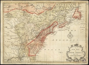
A new and accurate map of North America : laid down according to the latest, and most approved observations and discoveries
11202.
A new and accurate map of North America : laid down according to the latest, and most approved observations and discoveries
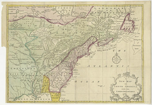
11203.
A new and accurate map of North America laid down according to the latest and most approved observations, and discoveries
11204.
A new map of North America : with the British, French, Spanish, Dutch & Danish dominions on that great continent, and the West...
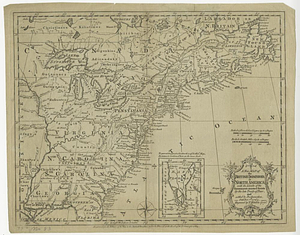
11205.
A new map of North America from the latest discoveries
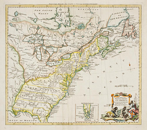
11206.
A new map of North America from the latest discoveries 1763
11207.
A new map of North America wherein the British Dominions in the continent of North America : and on the islands of the West...
11208.
A new map of the British dominions in North America with the limits of the governments annexed thereto by the late treaty of...
11209.
A new map of the British empire in Nth. America, drawn from the latest authorities
11210.
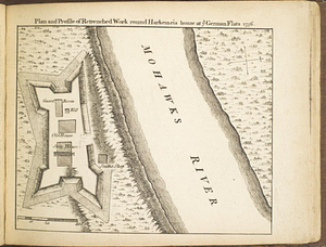
Plan and profile of retrenched work round Harkemeis house at ye German Flats 1756
11211.
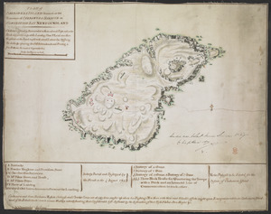
PLAN of CARBONERA ISLAND situated at the Entrance of CARBONERA HARBOUR in CONCEPTION BAY NEWFOUNDLAND
11212.
Plan of Fort Edward situated lat. 43 lon. 72 30'
11213.
Plan of Fort Frederick at Albany
11214.
A plan of Fort Frederick, situated at the entrance of St. John's River : lat 47 long. 66 30'
11215.
Plan of Fort Frontenac
11216.
Plan of Fort Niagara, with its environ
11217.
A plan of Fort Ontario
11218.
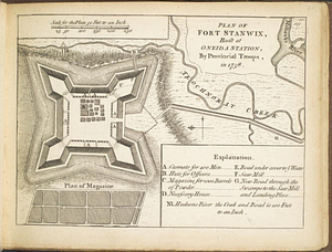
Plan of Fort Stanwix, built at Oneida Station, by provincial troops, in 1758
11219.
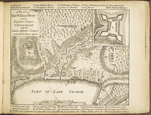
A plan of Fort William Henry and the English camps & retrenchments with the French different camps and attack there upon
11220.
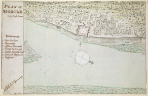
PLAN of MOBILE
‹ Prev
Next ›
1
2
…
557
558
559
560
561
562
563
564
565
…
669
670