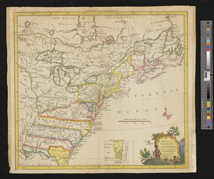
A new map of the British dominions in North America with the limits of the governments annexed thereto by the late treaty of peace, and settled by proclamation October 7th 1763
This map is also available in American Revolutionary Geographies Online (ARGO), a collections portal especially built for material relating to the American Revolutionary War Era. Visit ARGO to learn more about this item and explore the historical geography of North America in the late eighteenth century.
Item Information
- Title:
- A new map of the British dominions in North America with the limits of the governments annexed thereto by the late treaty of peace, and settled by proclamation October 7th 1763
- Title (alt.):
-
To prevent too great a contraction of the genl. map, Florida is continued here on the same scale
- Creator:
- Kitchin, Thomas, 1719-1784
- Name on Item:
-
engraved by T. Kitchin geogr.
- Date:
-
[1763]
- Format:
-
Maps/Atlases
- Location:
- William L. Clements Library
- Collection (local):
-
William L. Clements Library Collection
- Subjects:
-
East (U.S.)--Maps
Canada, Eastern--Maps
- Places:
-
Eastern United States (area)
Canada
- Extent:
- 1 map ; 24 x 30.5 cm.
- Terms of Use:
-
The University of Michigan Library provides access to these materials for educational and research purposes. These materials may be under copyright. If you decide to use any of these materials, you are responsible for making your own legal assessment and securing any necessary permission. If you have questions about the collection, please contact the William L. Clements Library.
Contact host institution for more information.
- Place of origin:
-
[London]
- Scale:
-
Scale 1:11,500,000.
- Language:
-
English
- Catalog Record:
-
Catalog record
- Notes:
-
Below neat line: Engraved for the history of the war in the Annual register, and to be placed at the end of the volume for 1763.
- Notes (date):
-
This date is inferred.
- Identifier:
-
929
- Barcode:
-
B1938882