Toggle navigation
LMEC Home
Exhibitions
Georeferencing
Tools for Teachers
Collections
My Favorites
Sign Up / Log In
Search
Search the map portal
Map Collection
Map Collection
Map Sets
Search
Search
Search for
Search In
All Fields
Creator
Title
Subject
Place
Search All Digital Collections
Advanced Search
2261 Results
My Search
Start Over
london
Remove constraint london
Filter your Search
Place
North and Central America
1,479
United States
921
Europe
363
Canada
347
North America
194
New York
128
Massachusetts
111
New England
104
more
Place
»
Topic
North America--Maps--Early works to 1800
137
Coasts--Nova Scotia--Maps
64
New England--Maps--Early works to 1800
57
United States--History--French and Indian War, 1754-1763--Maps
57
United States--History--French and Indian War, 1754-1763--Maps, Manuscript--Early works to 1800
56
United States--Maps--Early works to 1800
54
United States--History--Revolution, 1775-1783--Maps
40
Nova Scotia--Maps--Early works to 1800
39
more
Topic
»
Date
Date range begin
–
Date range end
Current results range from
1624
to
1999
View distribution
Creator
Des Barres, Joseph F. W. (Joseph Frederick Wallet), 1722-1824
242
Jefferys, Thomas, -1771
167
George, III, King of Great Britain, 1738-1820
149
George, IV, King of Great Britain, 1762-1830
148
Sayer, Robert, 1725-1794
115
Faden, William, 1749-1836
109
Moll, Herman, d. 1732
72
Robert Sayer and John Bennett (Firm)
57
more
Creator
»
Format
Maps/Atlases
2,219
Manuscripts
161
Prints
23
Drawings/Illustrations
15
Books
4
Objects/Artifacts
1
Georeferenced
Yes
137
No
2,124
Collection
American Revolutionary War-Era Maps
1,355
Norman B. Leventhal Map & Education Center Collection
1,305
Maritime Charts and Atlases
263
British Library Collection
163
William L. Clements Library Collection
160
Boston and New England Maps
152
Richard H. Brown Revolutionary War Map Collection at Mount Vernon
146
MacLean Collection Map Library
140
more
Collection
»
Available to use
No known restrictions
1,271
Creative Commons license
569
Search Constraints
Sort by relevance
relevance
title
date (asc)
date (desc)
Number of results to display per page
20 per page
10
per page
20
per page
50
per page
100
per page
View results as:
grid view
map view
Search Results
901.
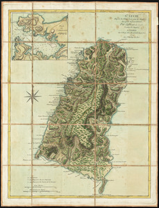
Ste. Lucie : d'après les plans levés par les Anglois lors qu'ils le possedoient
902.
Carte d'une partie de l'Amérique Septentrionale : pour servir à l'intellegence du mémoire sur les prétentions des Anglois...
903.
A chart of the coast of New York, New Jersey, Pensilvania, Maryland, Virginia, North Carolina, &c
904.
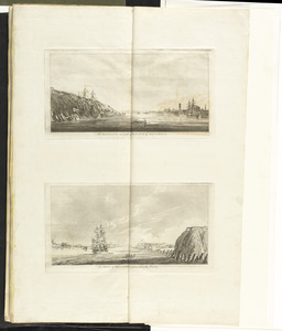
The harbour and part of the town of Havannah : The entrance of Havannah, from within the harbour
905.
A large draft of the island Antegua
906.
A map of South Carolina and a part of Georgia : containing the whole sea-coast; all the islands, inlets, rivers, creeks,...
907.
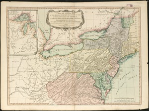
A new and general map of the middle dominions belonging to the United States of America, viz. Virginia, Maryland, the...
908.
A new map of Nova Scotia, and Cape Britain : with the adjacent parts of New England and Canada, composed from a great number of...
909.
A new map of Nova Scotia, and Cape Britain : with the adjacent parts of New England and Canada, composed from a great number of...
910.
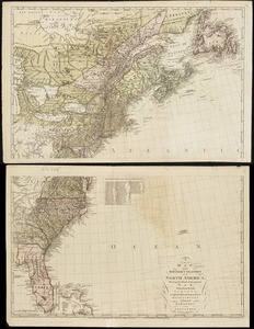
A new map of the British colonies in North America, shewing the seat of the present war, taken from the best surveys, compared...
911.
A new mapp of the upper part of the Rhine containing all Switzerland the circle of Swabia Alsatia the Palatine of the Rhine...
912.
A new mapp of ye seat of the warr in the counties of Namur and Hainault wherin perticulerly is described ye cittyes town's...
913.
A plan of Quebec the capital of New France or Canada
914.
A plan of the field of battle and disposition of the troops, as they were on the march at the time of the attack on the 9th of...
915.
A plan of the field of battle and disposition of the troops, as they were on the march at the time of the attack on the 9th of...
916.
W.H. Smith & Son's new railway map of the British Isles
917.
A new map of the province of Quebec, : according to the Royal proclamation, of the 7th of October 1763
918.
Les Vierges, levées par les Anglais, et par les Dannois : traduit de l'Anglais
919.
Païs cedés, sheet IId, containing the Peninsula & Gulf of Florida, with the Bahama Islands
920.
Mappa æstivarum insularum alias Bermudas dictarum ad ostia Mexicani ... accurate descr = A Mapp of the Sommer Islands once...
‹ Prev
Next ›
1
2
…
42
43
44
45
46
47
48
49
50
…
113
114