Toggle navigation
LMEC Home
Exhibitions
Georeferencing
Tools for Teachers
Collections
My Favorites
Sign Up / Log In
Search
Search the map portal
Map Collection
Map Collection
Map Sets
Search
Search
Search for
Search In
All Fields
Creator
Title
Subject
Place
Search All Digital Collections
Advanced Search
13680 Results
My Search
Start Over
Date facet yearly ssim
2000
to
2019
Remove constraint Date facet yearly ssim: <span class='from'>2000</span> to <span class='to'>2019</span>
Filter your Search
Place
North and Central America
10,344
United States
8,475
Massachusetts
2,789
Suffolk (county)
1,677
Boston
1,633
Europe
1,415
Canada
950
New York
649
more
Place
»
Topic
Boston (Mass.)--Maps
747
City planning--Massachusetts--Boston--Maps
418
United States--History--Revolution, 1775-1783--Maps
329
United States--Maps
322
Real property--Massachusetts--Boston--Maps
254
Urban renewal--Massachusetts--Boston--Maps
254
Massachusetts--Maps
231
Insurance surveys
197
more
Topic
»
Date
Date range begin
–
Date range end
Current results range from
1482
to
2023
View distribution
Creator
United States. Hydrographic Office
597
Boston Redevelopment Authority
404
Des Barres, Joseph F. W. (Joseph Frederick Wallet), 1722-1824
247
Royal United Services Institute for Defence and Security Studies
160
Jefferys, Thomas, -1771
154
George, III, King of Great Britain, 1738-1820
152
George, IV, King of Great Britain, 1762-1830
151
O.H. Bailey & Co
148
more
Creator
»
Format
Maps/Atlases
13,499
Manuscripts
985
Prints
102
Books
49
Drawings/Illustrations
44
Photographs
15
Objects/Artifacts
13
Documents
7
more
Format
»
Georeferenced
Yes
979
No
12,701
Collection
Norman B. Leventhal Map & Education Center Collection
9,096
American Revolutionary War-Era Maps
3,305
Boston and New England Maps
2,915
Urban Maps
2,471
Maritime Charts and Atlases
1,169
William L. Clements Library Collection
910
Library of Congress Collection
618
Boston Redevelopment Authority Collection
475
more
Collection
»
Available to use
No known restrictions
10,246
Creative Commons license
1,678
Search Constraints
Sort by relevance
relevance
title
date (asc)
date (desc)
Number of results to display per page
20 per page
10
per page
20
per page
50
per page
100
per page
View results as:
grid view
map view
Search Results
7981.
Pacific Ocean, New Zealand : from surveys in H.M. ships Acheron, & Pandora
7982.
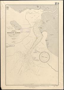
Pacific Ocean, Sandwich Islands, south coast of Oahu, Honolulu Harbor : from surveys by British and United States officers to 1888
7983.
Pacific Ocean, Solomon Is., part of the west coast of Bougainville Island
7984.
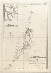
Pacific Ocean, western Caroline Islands, the Pelew (Palau) Group : from a reconnaissance by the officers of the Imp. German...
7985.
Païs cedés, sheet IId, containing the Peninsula & Gulf of Florida, with the Bahama Islands
7986.
Païs cedés, sheet Ist, containing the coast of Louisiana and Florida
7987.
Palatinatus ad Rhenum
7988.
[Palestina]
7989.
Palestine
7990.
Palestine or Canaan
7991.
Palmer
7992.
Pampanga
7993.
Panama route, map showing location of proposed canal
7994.
Panay, military district no 4, Department of the Visayas
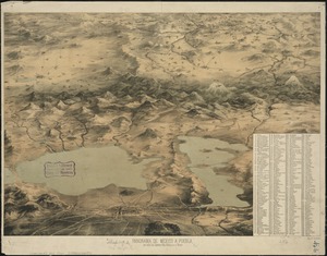
7995.
Panorama de Mexico a puebla, con todos los caminos, rios, poblaciones y montes
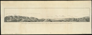
7996.
Panorama from the Pinnacle ("Acorn Hill," 1371'), Lyme, N.H.
7997.
Panorama orografico e pittoresco della città e contorni di Milano preso dalla somità della cattedrale
7998.
Panoramic view from Bunker Hill Monument
7999.
Panoramic view from Strawberry Hill, one of the St. Andrews Mountains, Jamaica
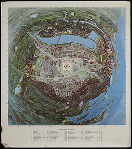
8000.
Panoramic view of Boston centered on the Prudential Tower
‹ Prev
Next ›
1
2
…
396
397
398
399
400
401
402
403
404
…
683
684


![[Palestina]](https://bpldcassets.blob.core.windows.net/derivatives/images/commonwealth:7h14b116r/image_thumbnail_300.jpg)