[Palestina]
![[Palestina]](https://bpldcassets.blob.core.windows.net/derivatives/images/commonwealth:7h14b116r/image_access_800.jpg)
Item Information
- Title:
- [Palestina]
- Creator:
- Ptolemy, 2nd cent
- Printer:
- Hol, Lienhart
- Date:
-
[1482]
- Format:
-
Maps/Atlases
- Location:
-
Boston Public Library
Norman B. Leventhal Map & Education Center - Collection (local):
-
Norman B. Leventhal Map & Education Center Collection
- Subjects:
-
Palestine--Maps--Early works to 1800
Israel--Maps--Early works to 1800
- Places:
-
State of Palestine
Israel
- Extent:
- 1 map : hand col. ; 23 x 49 cm.
- Terms of Use:
-
No known copyright restrictions.
No known restrictions on use.
- Publisher:
-
Ulm :
Lienhart Hol
- Scale:
-
Scale [ca. 1:670,000]
- Language:
-
Latin
- Notes:
-
Title supplied by cataloger.
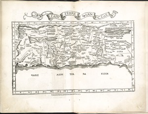
Map of Palestine.
Oriented with north to the left.
Relief shown by brown coloring.
Engraved on wood with place names in moveable type.
Includes names of places and natural features.
In margin: notes on latitude.
Appears in the author's Geographia. Ulm : Lienhart Hol, 16 July 1482.
Like all the modern maps of Palestine added to the early printed editions of Ptolemy, this was copied from Petrus Vesconte's map of Palestine first published by Marino Sanuto, ca. 1320.
One of 5 'modern' maps of non-Ptolemaic design, executed by Pietro Vesconte for Marino sanudo's "Liber secretorum fidelium crucis" early in the 14th century.
Text in Latin.
Cataloging, conservation, and digitization made possible in part by The National Endowment for the Humanities: Exploring the human endeavor.
Atlas scanned by Internet Archive http://www.archive.org/details/cosmographia00ptol
- Notes (date):
-
This date is inferred.
- Identifier:
-
06_01_000857
- Call #:
-
G1005.P7 1482
- Barcode:
-
30000003825248