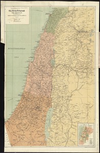
Palestine


Item Information
- Title:
- Palestine
- Cartographer:
- American Geographical Society of New York
- Date:
-
[1918?]
- Format:
-
Maps/Atlases
- Location:
-
Boston Public Library
Norman B. Leventhal Map & Education Center - Collection (local):
-
Norman B. Leventhal Map & Education Center Collection
- Subjects:
-
Palestine--Maps
- Places:
-
Palestine (area)
- Extent:
- 1 map on 2 sheets ; 85 x 109 cm, on sheets 101 x 66 cm
- Terms of Use:
-
No known copyright restrictions.
No known restrictions on use.
- Publisher:
-
New York :
American Geographical Society
- Scale:
-
Scale 1:500,000
- Language:
-
English
- Notes:
-
Relief shown by hachures and spot heights.
- Identifier:
-
06_01_015321A
06_01_015321B
- Call #:
-
G7500 1918 .A44
- Barcode:
-
39999085935037