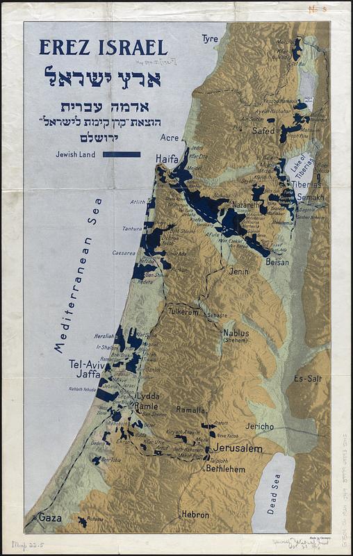
Erez Israel = Erets Yiśraʼel : adamah ʻIvrit
Item Information
- Title:
- Erez Israel = Erets Yiśraʼel : adamah ʻIvrit
- Cartographer:
- Jewish National Fund
- Date:
-
[1924–1926]
- Format:
-
Maps/Atlases
- Location:
-
Boston Public Library
Norman B. Leventhal Map & Education Center - Collection (local):
-
Norman B. Leventhal Map & Education Center Collection
- Subjects:
-
Palestine--Maps
Palestine--History--1917-1948--Sources
Jews--History--20th century
Zionism--History
- Places:
-
Palestine (area)
- Extent:
- 1 map : color ; 61 x 37 cm
- Terms of Use:
-
No known copyright restrictions.
No known restrictions on use.
- Publisher:
-
Yerushalayim :
Ḳeren ḳayemet le-Yiśraʼel
- Scale:
-
Scale approximately 1:350,000
- Language:
-
English
Hebrew
- Notes:
-
Relief shown by hypsometric tints and hill shading.
Shows Jewish areas in Palestine.
- Notes (date):
-
This date is inferred.
- Identifier:
-
06_01_017022
- Call #:
-
G7501.S6 1924 .J49
- Barcode:
-
39999085935045