Toggle navigation
LMEC Home
Exhibitions
Georeferencing
Tools for Teachers
Collections
My Favorites
Sign Up / Log In
Search
Search the map portal
Map Collection
Map Collection
Map Sets
Search
Search
Search for
Search In
All Fields
Creator
Title
Subject
Place
Search All Digital Collections
Advanced Search
2261 Results
My Search
Start Over
london
Remove constraint london
Filter your Search
Place
North and Central America
1,492
United States
943
Europe
363
Canada
347
North America
194
New York
129
Massachusetts
117
New England
104
more
Place
»
Topic
North America--Maps--Early works to 1800
137
Coasts--Nova Scotia--Maps
64
New England--Maps--Early works to 1800
57
United States--History--French and Indian War, 1754-1763--Maps
57
United States--History--French and Indian War, 1754-1763--Maps, Manuscript--Early works to 1800
56
United States--Maps--Early works to 1800
54
United States--History--Revolution, 1775-1783--Maps
40
Nova Scotia--Maps--Early works to 1800
39
more
Topic
»
Date
Date range begin
–
Date range end
Current results range from
1624
to
1999
View distribution
Creator
Des Barres, Joseph F. W. (Joseph Frederick Wallet), 1722-1824
242
Jefferys, Thomas, -1771
167
George, III, King of Great Britain, 1738-1820
149
George, IV, King of Great Britain, 1762-1830
148
Sayer, Robert, 1725-1794
115
Faden, William, 1749-1836
109
Moll, Herman, d. 1732
72
Robert Sayer and John Bennett (Firm)
57
more
Creator
»
Format
Maps/Atlases
2,219
Manuscripts
161
Prints
23
Drawings/Illustrations
15
Books
4
Objects/Artifacts
1
Georeferenced
Yes
137
No
2,124
Collection
American Revolutionary War-Era Maps
1,355
Norman B. Leventhal Map & Education Center Collection
1,305
Maritime Charts and Atlases
263
British Library Collection
163
William L. Clements Library Collection
160
Boston and New England Maps
152
Richard H. Brown Revolutionary War Map Collection at Mount Vernon
146
MacLean Collection Map Library
140
more
Collection
»
Available to use
No known restrictions
1,271
Creative Commons license
569
Search Constraints
Sort by relevance
relevance
title
date (asc)
date (desc)
Number of results to display per page
20 per page
10
per page
20
per page
50
per page
100
per page
View results as:
grid view
map view
Search Results
781.
Antigua
782.
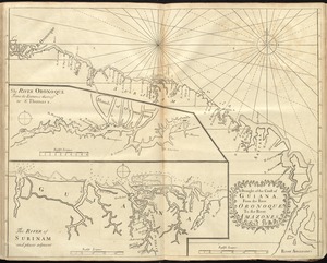
A draught of the coast of Guiana, from the river Oronoque to the river Amazones
783.
France
784.
The Gut of Canso : which divides ... cables distance
785.
Leith Harbour ... : Prospect Harbour ... Bristol Bay ... Sambro Harbour
786.
Map of China : compiled from original surveys & sketches
787.
Map of the northern provinces of the United States
788.
North view of Pensacola, on the island of Santa Rosa ; Plan of the harbour and settlement of Pensacola
789.
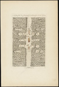
A plan of the line of march of the detachment from the little Meadows
790.
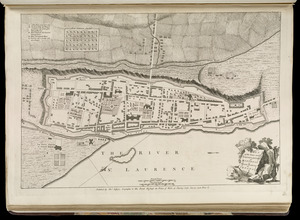
Plan of the town and fortifications of Montreal or Ville Marie in Canada
791.
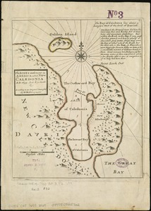
The Scots settlement in America called New Caledonia, A.D. 1699
792.
The United States of North America : with the British territories and those of Spain according to the treaty of 1784
793.
Standard railway map of South Africa = Standaard spoorwegkaart van Suidafrika
794.
The states of Maryland and Delaware from the latest surveys, 1799
795.
A draught of New York from the Hook to New York Town
796.
England
797.
Jamaica
798.
Map of the middle states of America : comprehends New-York, New-Jersey, Pennsylvania, Delaware, and the territory N.W. of Ohio
799.
Orbis Romani pars occidentalis
800.
Plan de l'isle de la Grenade : ou sont marqués dans leur juste position, les ports et mouillages, les ville et bourgs, les...
‹ Prev
Next ›
1
2
…
36
37
38
39
40
41
42
43
44
…
113
114