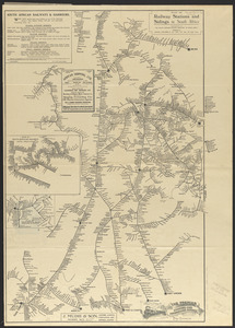
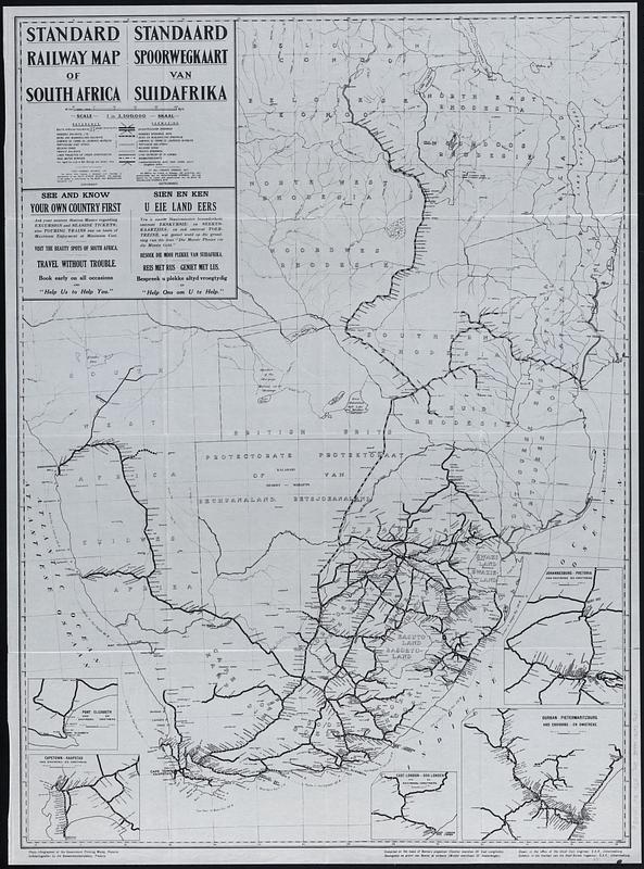
Standard railway map of South Africa = Standaard spoorwegkaart van Suidafrika
Item Information
- Title:
- Standard railway map of South Africa = Standaard spoorwegkaart van Suidafrika
- Cartographer:
- South African Railways and Harbours
- Publisher:
- Government Printing Works (South Africa)
- Name on Item:
-
drawn in the office of the Chief Civil Engineer, S.A.R = geteken in die Kantoor van die Hoof-Siviele Ingenieur, S.A.S.
- Date:
-
1925
- Format:
-
Maps/Atlases
- Location:
-
Boston Public Library
Norman B. Leventhal Map & Education Center - Collection (local):
-
Norman B. Leventhal Map & Education Center Collection
- Subjects:
-
Africa, Southern--Maps
Railroads--Africa, Southern--Maps
- Places:
-
Southern Africa (area)
- Extent:
- 1 map ; 93 x 68 cm
- Terms of Use:
-
No known copyright restrictions.
No known restrictions on use.
- Publisher:
-
Pretoria :
Government Printing Works
- Scale:
-
Scale 1:3,500,000
- Projection:
- Bonne's projection (central meridian 25° east longitude)
- Language:
-
English
Afrikaans
- Notes:
-
Insets: Port Elizabeth and environs = Port Elizabeth en omstreke -- Cape Town and environs = Kaapstad en omstreke -- Johannesburg and environs = Pretoria en omstreke -- Durban-Pietermaritzburg and environs = Durban-Pietermaritzburg en omstreke -- East London and environs = Oos Londen en omstreke.
- Notes (language):
-
In English and Afrikaans.
- Identifier:
-
06_01_019297
- Call #:
-
G8481.P3 1925 .S68
- Barcode:
-
39999085935631