Toggle navigation
LMEC Home
Exhibitions
Georeferencing
Tools for Teachers
Collections
My Favorites
Sign Up / Log In
Search
Search the map portal
Map Collection
Map Collection
Map Sets
Search
Search
Search for
Search In
All Fields
Creator
Title
Subject
Place
Search All Digital Collections
Advanced Search
124 Results
My Search
Start Over
Date
1805
to
1809
Remove constraint Date: <span class='from'>1805</span> to <span class='to'>1809</span>
Filter your Search
Place
North and Central America
86
United States
67
Massachusetts
19
Europe
15
Boston
12
Suffolk (county)
12
Canada
6
New York
5
more
Place
»
Topic
Boston (Mass.)--Maps
9
United States--Maps
6
China--Maps
4
Korea--Maps
4
Manuscript maps
4
New Jersey--Maps
4
Canada--Maps
3
Massachusetts--Maps
3
more
Topic
»
Date
1805
to
1809
[remove]
124
Date range begin
–
Date range end
Current results range from
1760
to
1990
1805
to
1805
50
1806
to
1806
80
1807
to
1807
64
1808
to
1808
58
1809
to
1809
57
Creator
Carey, Mathew, 1760-1839
21
Barker, W. (William), active 1795-1803
13
Neele, Samuel John, 1758-1824
5
Doolittle, Amos, 1754-1832
4
Bulfinch, Charles, 1763-1844
3
Carleton, Osgood, 1742-1816
3
Lewis, Samuel, 1753 or 4-1822
3
Arrowsmith, Aaron, 1750-1823
2
more
Creator
»
Format
Maps/Atlases
124
Manuscripts
25
Georeferenced
Yes
20
No
104
Collection
Norman B. Leventhal Map & Education Center Collection
87
American Revolutionary War-Era Maps
30
Boston and New England Maps
24
Urban Maps
12
Library of Congress Collection
9
MacLean Collection Map Library
6
Maritime Charts and Atlases
5
New York Public Library Collection
5
more
Collection
»
Available to use
No known restrictions
88
Creative Commons license
18
Search Constraints
Sort by relevance
relevance
title
date (asc)
date (desc)
Number of results to display per page
20 per page
10
per page
20
per page
50
per page
100
per page
View results as:
grid view
map view
Search Results
61.
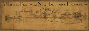
A Map of the Trenton and New-Brunswick Turnpike-road
62.
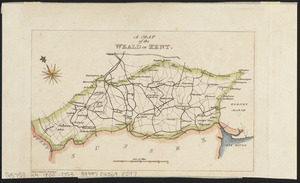
A map of the Weald of Kent
63.
[Map of W. Dall's lots in Athens County, Washington County, and Gallia County, Ohio]
64.
Maryland
65.
Massachusetts
66.
Massachusetts
67.
Mississippi Territory and Georgia
68.
A new chart of the Cape Verd Islands, from the latest authorities
69.
New Jersey
70.
A new map of part of the United States of North America, containing those of New York, Vermont, New Hampshire, Massachusets...
71.
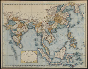
A new map of the East Indies and China from the best authorities
72.
A new map of the United States including part of Louisiana : from the best authorities
73.
A new map of the United States of America including part of Louisiana : part of Canada & of East Florida and the whole of West...
74.
A new plan of Boston : drawn from the best authorities with the latest improvements, additionas and corrections
75.
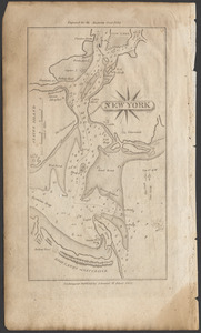
New York
76.
New York
77.
North America
78.
North Carolina
79.
Ohio and N.W. Territory
80.
Pennsylvania
‹ Prev
Next ›
1
2
3
4
5
6
7
![[Map of W. Dall's lots in Athens County, Washington County, and Gallia County, Ohio]](https://bpldcassets.blob.core.windows.net/derivatives/images/commonwealth:w9505s00n/image_thumbnail_300.jpg)


![A new map of part of the United States of North America, containing those of New York, Vermont, New Hampshire, Massachusets [sic], Connecticut, Rhode Island, Pennsylvania, New Jersey, Delaware, Maryland and Virginia](https://bpldcassets.blob.core.windows.net/derivatives/images/commonwealth:6t053p06v/image_thumbnail_300.jpg)