Toggle navigation
LMEC Home
Exhibitions
Georeferencing
Tools for Teachers
Collections
My Favorites
Sign Up / Log In
Search
Search the map portal
Map Collection
Map Collection
Map Sets
Search
Search
Search for
Search In
All Fields
Creator
Title
Subject
Place
Search All Digital Collections
Advanced Search
90 Results
My Search
Start Over
Date
1735
to
1739
Remove constraint Date: <span class='from'>1735</span> to <span class='to'>1739</span>
Filter your Search
Place
North and Central America
47
United States
26
Glynn (county)
10
Saint Simons Island
8
Canada
7
Europe
7
New England
6
North America
6
more
Place
»
Topic
Saint Simons Island (Ga.)--Maps, Manuscript--Early works to 1800
8
Military art and science--Georgia--Saint Simons Island--Maps, Manuscript--Early works to 1800
7
Fortification--Georgia--Saint Simons Island--Maps, Manuscript--Early works to 1800
5
Jekyll Island (Ga.)--Maps, Manuscript--Early works to 1800
5
Nautical charts--Atlantic Coast (North America)--Early works to 1800
3
New England--Maps--Early works to 1800
3
Western Hemisphere--Maps--Early works to 1800
3
World maps--Early works to 1800
3
more
Topic
»
Date
1735
to
1739
[remove]
90
Date range begin
–
Date range end
Current results range from
1699
to
1800
1735
to
1735
34
1736
to
1736
36
1737
to
1737
52
1738
to
1738
36
1739
to
1739
33
Creator
George, III, King of Great Britain, 1738-1820
14
George, IV, King of Great Britain, 1762-1830
13
Moll, Herman, d. 1732
10
Thomas, John, the Elder
10
Southack, Cyprian, 1662-1745
5
Nolin, Jean Baptiste, 1686-1762
3
Thornton, John, 1641-1708
3
Amherst, Jeffery Amherst, Baron, 1717-1797
2
more
Creator
»
Format
Maps/Atlases
90
Manuscripts
13
Georeferenced
Yes
4
No
86
Collection
Norman B. Leventhal Map Center Collection
58
Maritime Charts and Atlases
28
American Revolutionary War-Era Maps
23
British Library Collection
19
William L. Clements Library Collection
7
Boston and New England Maps
6
Urban Maps
4
MacLean Collection Map Library
3
more
Collection
»
Available to use
No known restrictions
56
Creative Commons license
24
Search Constraints
Sort by relevance
relevance
title
date (asc)
date (desc)
Number of results to display per page
20 per page
10
per page
20
per page
50
per page
100
per page
View results as:
grid view
map view
Search Results
61.
A new generall chart for the West Indies of E. Wrights projection vul. Mercators chart
62.
A new map of North America shewing its principal divisions, chief cities, townes, rivers, mountains &c
63.
A new map of the terraqueous globe according to the latest discoveries and most general divisions of it into continents and oceans
64.
A new mapp of Carolina
65.
A New Plan of ye Great Town of BOSTON in New England in AMERICA with the many Additionall Buildings & New Streets to the Year,...
66.
Part of modern Orange County
67.
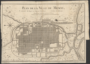
Plan de la ville de Meaco
68.
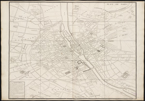
Plan de Paris : commencé l'année 1734
69.
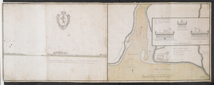
Plan du fort de Chouéghen de la Riviere Et de terrain aux Environs au Sud du Lac Ontario
70.
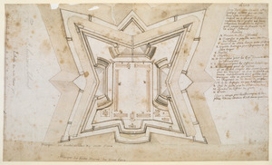
Plan dun Fort convenable en quelque endroit ce que soit dune Cote maritime Auquel on a changé la figure reguliere du 1.r...
71.
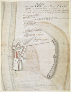
PLAN dun petit FORT pour l'Isle de S.t ANDRE capable de contenir outre les Magazins, des Barraques pour 200 Hommes de Garrison,...
72.
A plan of the city and harbour of Havanna situated on the island of Cuba
73.
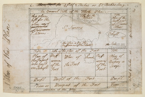
A Plan of the Plan
74.
A PLAN of the Rivers and Boundary Lines referr'd to in ye Proceedings & Judgment of ye Commissioners for adjusting the Bounds...
75.
A pocket companion of Ireland : containing all the cities, market towns, boroughs, all ye great roads, and principal cross...
76.
Port Bonavista
77.
Proposed Maryland / Pennsylvania Boundary
78.
River valley with several foothills and swamp
79.
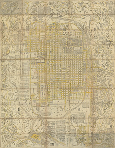
Shinsen zouho Kyo oezu
80.
Shinsen zouho Kyo oezu
‹ Prev
Next ›
1
2
3
4
5