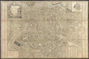
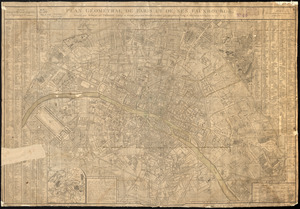
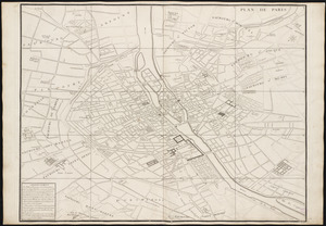
Plan de Paris : commencé l'année 1734
Item Information
- Title:
- Plan de Paris : commencé l'année 1734
- Title (alt.):
-
Turgot map of Paris
- Cartographer:
- Bretez, Louis, -1738
- Engraver:
- Lucas, Claude, active 18th century
- Engraver:
- Aubin
- Contributor:
- Turgot, Michel-Etienne, 1690-1751
- Name on Item:
-
dessiné et gravé sous les ordres de Messire Michel Etienne Turgot ... [et al.] ; levé et dessiné par Louis Bretez ; gravé par Claude Lucas ; et écrit par Aubin
- Date:
-
[1739?]
- Format:
-
Maps/Atlases
- Location:
-
Boston Public Library
Norman B. Leventhal Map & Education Center - Collection (local):
-
Norman B. Leventhal Map & Education Center Collection
- Subjects:
-
Paris (France)--Maps--Early works to 1800
Paris (France)--Aerial views--Early works to 1800
- Places:
-
FranceÎle-de-France (region)Paris
- Extent:
- 20 [i.e. 21] double plans ; sheets 63 x 90 cm
- Terms of Use:
-
No known copyright restrictions.
No known restrictions on use.
- Publisher:
-
[Paris?] :
[Publisher not identified]
- Scale:
-
Scale approximately 1:1,800
- Language:
-
French
- Notes:
-
Bird's-eye view of Paris.
Title from plans 18 and 19.
Consists of 20 numbered sectional plans of Paris.
- Identifier:
-
06_01_001799
06_01_001803 to 06_01_001821
- Call #:
-
G1844.P3 .B74 1739
- Barcode:
-
39999058991009