Toggle navigation
LMEC Home
Exhibitions
Georeferencing
Tools for Teachers
Collections
My Favorites
Sign Up / Log In
Search
Search the map portal
Map Collection
Map Collection
Map Sets
Search
Search
Search for
Search In
All Fields
Creator
Title
Subject
Place
Search All Digital Collections
Advanced Search
13385 Results
My Search
Start Over
Date facet yearly ssim
1830
to
1834
Remove constraint Date facet yearly ssim: <span class='from'>1830</span> to <span class='to'>1834</span>
Filter your Search
Place
North and Central America
10,111
United States
8,249
Massachusetts
2,691
Suffolk (county)
1,664
Boston
1,621
Europe
1,386
Canada
949
New York
640
more
Place
»
Topic
Boston (Mass.)--Maps
741
City planning--Massachusetts--Boston--Maps
418
United States--History--Revolution, 1775-1783--Maps
329
United States--Maps
315
Urban renewal--Massachusetts--Boston--Maps
254
Real property--Massachusetts--Boston--Maps
252
Massachusetts--Maps
219
Insurance surveys
197
more
Topic
»
Date
Date range begin
–
Date range end
Current results range from
1482
to
2023
View distribution
Creator
United States. Hydrographic Office
595
Boston Redevelopment Authority
403
Des Barres, Joseph F. W. (Joseph Frederick Wallet), 1722-1824
247
Royal United Services Institute for Defence and Security Studies
160
Jefferys, Thomas, -1771
154
George, III, King of Great Britain, 1738-1820
152
George, IV, King of Great Britain, 1762-1830
151
O.H. Bailey & Co
148
more
Creator
»
Format
Maps/Atlases
13,205
Manuscripts
985
Prints
102
Books
49
Drawings/Illustrations
44
Photographs
15
Objects/Artifacts
13
Documents
7
more
Format
»
Georeferenced
Yes
979
No
12,406
Collection
Norman B. Leventhal Map & Education Center Collection
8,891
American Revolutionary War-Era Maps
3,305
Boston and New England Maps
2,804
Urban Maps
2,397
Maritime Charts and Atlases
1,150
William L. Clements Library Collection
910
Library of Congress Collection
618
Boston Redevelopment Authority Collection
475
more
Collection
»
Available to use
No known restrictions
9,952
Creative Commons license
1,677
Search Constraints
Sort by relevance
relevance
title
date (asc)
date (desc)
Number of results to display per page
20 per page
10
per page
20
per page
50
per page
100
per page
View results as:
grid view
map view
Search Results
7781.
Païs cedés, sheet Ist, containing the coast of Louisiana and Florida
7782.
Palatinatus ad Rhenum
7783.
[Palestina]
7784.
Palestine
7785.
Palestine or Canaan
7786.
Palmer
7787.
Pampanga
7788.
Panama route, map showing location of proposed canal
7789.
Panay, military district no 4, Department of the Visayas
7790.
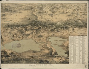
Panorama de Mexico a puebla, con todos los caminos, rios, poblaciones y montes
7791.
Panorama from the Pinnacle ("Acorn Hill," 1371'), Lyme, N.H.
7792.
Panorama orografico e pittoresco della città e contorni di Milano preso dalla somità della cattedrale
7793.
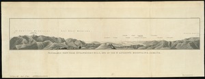
Panoramic view from Bunker Hill Monument
7794.
Panoramic view from Strawberry Hill, one of the St. Andrews Mountains, Jamaica
7795.
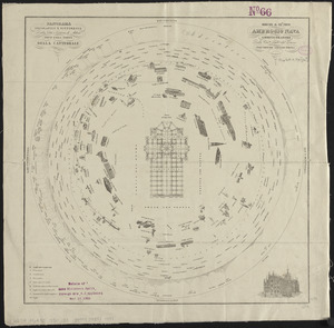
Panoramic view of Boston showing golden semicircle
7796.
[Panoramic view of Newport, Rhode Island and the harbor showing the position of the French fleet and troop encampments]
7797.
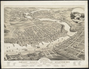
Panoramic view of the city of Calais, St. Stephen and Milltown : Washington Co. Maine, Charlotte Co. New Brunswick : mills,...
7798.
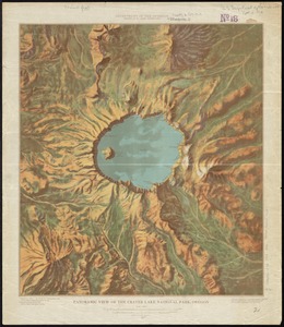
Panoramic view of the Crater Lake National Park, Oregon
7799.
[Panoramic view of the Gettysburg battlefield]
7800.
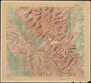
Panoramic view of the Glacier National Park, Montana
‹ Prev
Next ›
1
2
…
386
387
388
389
390
391
392
393
394
…
669
670


![[Palestina]](https://bpldcassets.blob.core.windows.net/derivatives/images/commonwealth:7h14b116r/image_thumbnail_300.jpg)


![[Panoramic view of Newport, Rhode Island and the harbor showing the position of the French fleet and troop encampments]](https://bpldcassets.blob.core.windows.net/derivatives/images/commonwealth:dz010v493/image_thumbnail_300.jpg)
![[Panoramic view of the Gettysburg battlefield]](https://bpldcassets.blob.core.windows.net/derivatives/images/commonwealth:xg94j2023/image_thumbnail_300.jpg)