Toggle navigation
LMEC Home
Exhibitions
Georeferencing
Tools for Teachers
Collections
My Favorites
Sign Up / Log In
Search
Search the map portal
Map Collection
Map Collection
Map Sets
Search
Search
Search for
Search In
All Fields
Creator
Title
Subject
Place
Search All Digital Collections
Advanced Search
13694 Results
My Search
Start Over
Date facet yearly ssim
1550
to
1599
Remove constraint Date facet yearly ssim: <span class='from'>1550</span> to <span class='to'>1599</span>
Filter your Search
Place
North and Central America
10,357
United States
8,484
Massachusetts
2,796
Suffolk (county)
1,678
Boston
1,634
Europe
1,419
Canada
950
New York
650
more
Place
»
Topic
Boston (Mass.)--Maps
748
City planning--Massachusetts--Boston--Maps
418
United States--History--Revolution, 1775-1783--Maps
329
United States--Maps
322
Real property--Massachusetts--Boston--Maps
254
Urban renewal--Massachusetts--Boston--Maps
254
Massachusetts--Maps
233
Insurance surveys
197
more
Topic
»
Date
Date range begin
–
Date range end
Current results range from
1482
to
2023
View distribution
Creator
United States. Hydrographic Office
597
Boston Redevelopment Authority
404
Des Barres, Joseph F. W. (Joseph Frederick Wallet), 1722-1824
247
Royal United Services Institute for Defence and Security Studies
160
Jefferys, Thomas, -1771
154
George, III, King of Great Britain, 1738-1820
152
George, IV, King of Great Britain, 1762-1830
151
O.H. Bailey & Co
148
more
Creator
»
Format
Maps/Atlases
13,513
Manuscripts
985
Prints
102
Books
49
Drawings/Illustrations
44
Photographs
15
Objects/Artifacts
13
Documents
7
more
Format
»
Georeferenced
Yes
979
No
12,715
Collection
Norman B. Leventhal Map & Education Center Collection
9,108
American Revolutionary War-Era Maps
3,305
Boston and New England Maps
2,921
Urban Maps
2,480
Maritime Charts and Atlases
1,169
William L. Clements Library Collection
910
Library of Congress Collection
618
Boston Redevelopment Authority Collection
475
more
Collection
»
Available to use
No known restrictions
10,260
Creative Commons license
1,678
Search Constraints
Sort by relevance
relevance
title
date (asc)
date (desc)
Number of results to display per page
20 per page
10
per page
20
per page
50
per page
100
per page
View results as:
grid view
map view
Search Results
7641.
North Atlantic Ocean, Newfoundland Bank, Virgin Rocks and shoals in the vicinity
7642.
North Atlantic Ocean, northwestern sheet
7643.
North Atlantic Ocean, southeast coast of North America, including the Bahamas and Greater Antilles
7644.
North Atlantic Ocean, southeast coast of North America, including the Bahamas and Greater Antilles
7645.
North Atlantic Ocean, southwestern sheet
7646.
North Atlantic Ocean, w. coast of Africa, Liberia, Cape Mount, the Sugury and Mahfah Rivers and Fisherman's Lake
7647.
North Atlantic Ocean, West Indies
7648.
North Atlantic Ocean, Windward Islands, Guadeloupe and adjacent islands : from a French survey of 1867 to 1869
7649.
North Atlantic track chart
7650.
North Atlantic--Azores, San Miguel : from a British survey in 1844
7651.
North Attleborough, Mass. 1878
7652.
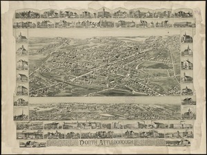
North Attleborough, Massachusetts : 1891
7653.
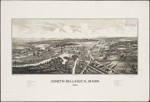
North Billerica, Mass : 1887
7654.
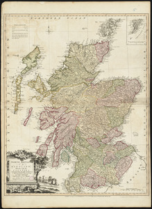
North Britain or Scotland divided into its counties : corrected from the best surveys & astronomical observations
7655.
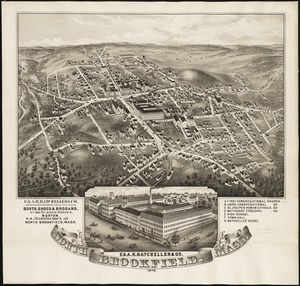
North Brookfield, Mass : 1878
7656.
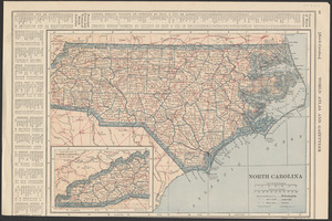
North Carolina
7657.
North Carolina
7658.
North Carolina & South Carolina
7659.
North Carolina form the best authorities. 1800
7660.
The north coast of the Gulf of Mexico, from St. Marks to Galveston
‹ Prev
Next ›
1
2
…
379
380
381
382
383
384
385
386
387
…
684
685