Toggle navigation
LMEC Home
Exhibitions
Georeferencing
Tools for Teachers
Collections
My Favorites
Sign Up / Log In
Search
Search the map portal
Map Collection
Map Collection
Map Sets
Search
Search
Search for
Search In
All Fields
Creator
Title
Subject
Place
Search All Digital Collections
Advanced Search
2261 Results
My Search
Start Over
london
Remove constraint london
Filter your Search
Place
North and Central America
1,479
United States
921
Europe
363
Canada
347
North America
194
New York
128
Massachusetts
111
New England
104
more
Place
»
Topic
North America--Maps--Early works to 1800
137
Coasts--Nova Scotia--Maps
64
New England--Maps--Early works to 1800
57
United States--History--French and Indian War, 1754-1763--Maps
57
United States--History--French and Indian War, 1754-1763--Maps, Manuscript--Early works to 1800
56
United States--Maps--Early works to 1800
54
United States--History--Revolution, 1775-1783--Maps
40
Nova Scotia--Maps--Early works to 1800
39
more
Topic
»
Date
Date range begin
–
Date range end
Current results range from
1624
to
1999
View distribution
Creator
Des Barres, Joseph F. W. (Joseph Frederick Wallet), 1722-1824
242
Jefferys, Thomas, -1771
167
George, III, King of Great Britain, 1738-1820
149
George, IV, King of Great Britain, 1762-1830
148
Sayer, Robert, 1725-1794
115
Faden, William, 1749-1836
109
Moll, Herman, d. 1732
72
Robert Sayer and John Bennett (Firm)
57
more
Creator
»
Format
Maps/Atlases
2,219
Manuscripts
161
Prints
23
Drawings/Illustrations
15
Books
4
Objects/Artifacts
1
Georeferenced
Yes
137
No
2,124
Collection
American Revolutionary War-Era Maps
1,355
Norman B. Leventhal Map & Education Center Collection
1,305
Maritime Charts and Atlases
263
British Library Collection
163
William L. Clements Library Collection
160
Boston and New England Maps
152
Richard H. Brown Revolutionary War Map Collection at Mount Vernon
146
MacLean Collection Map Library
140
more
Collection
»
Available to use
No known restrictions
1,271
Creative Commons license
569
Search Constraints
Sort by relevance
relevance
title
date (asc)
date (desc)
Number of results to display per page
20 per page
10
per page
20
per page
50
per page
100
per page
View results as:
grid view
map view
Search Results
521.
A new and accurate map of the English empire in North America : representing their rightful claim as confirm'd by charters, and...
522.
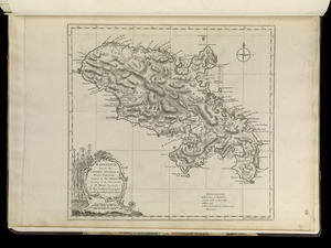
Martinico, one of the Caribbee Islands in the West Indies : subject to the French
523.
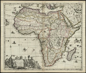
Africa
524.
Cattalina Harbor
525.
Falmouth Harbour
526.
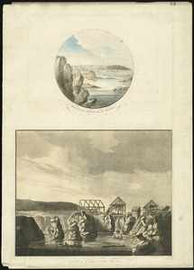
Mechios River near the mills : a sketch of Mechios mills
527.
Miramichi Bay
528.
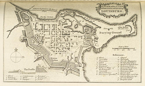
A plan of the city & fortifications of Louisbourg
529.
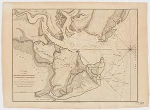
A plan of the town, bar, harbour and environs, of Charlestown in South Carolina : with all the channels, soundings,...
530.
Port Bonavista
531.
South entrance of Grand Passage : Cape St. Mary, N:E: one mile ; St. Mary's Bay
532.
Map of the New York & Boston Railway, with its connections with other railways
533.
The state of New Hampshire : compiled chiefly from actual surveys
534.
The state of New York, compiled from the best authorities
535.
The state of North Carolina from the best authorities, &c
536.
A general map of the middle British colonies, in America : viz Virginia, Màriland, Dèlaware, Pensilvania, New-Jersey,...
537.
A general map of the middle British colonies, in America : viz Virginia, Màriland, Dèlaware, Pensilvania, New-Jersey, New-York,...
538.
A map of Pennsylvania exhibiting not only the improved parts of that Province, but also its extensive frontiers : laid down...
539.
A new mapp of Africa divided into kingdoms and provinces
540.
Africa January rainfall -- Africa July rainfall
‹ Prev
Next ›
1
2
…
23
24
25
26
27
28
29
30
31
…
113
114