Toggle navigation
LMEC Home
Exhibitions
Georeferencing
Tools for Teachers
Collections
My Favorites
Sign Up / Log In
Search
Search the map portal
Map Collection
Map Collection
Map Sets
Search
Search
Search for
Search In
All Fields
Creator
Title
Subject
Place
Search All Digital Collections
Advanced Search
35 Results
My Search
Start Over
2000
Remove constraint 2000
Filter your Search
Place
North and Central America
32
United States
30
Massachusetts
12
Boston
6
Suffolk (county)
6
New York
4
Fort William Henry
3
Middlesex (county)
3
more
Place
»
Topic
Boston (Mass.)--Maps
4
Boston Public Library
2
Coasts--Florida--Maps--Early works to 1800
2
Florida--Maps--Early works to 1800
2
Fort William Henry (N.Y.)--History--French and Indian War, 1754-1763--Aerial views--Early works to 1800
2
Hudson River (N.Y. and N.J.)--Maps--Early works to 1800
2
Lake George (N.Y. : Town)--History--French and Indian War, 1754-1763--Aerial views--Early works to 1800
2
Lake George, Battle of, N.Y., 1755--Aerial views--Early works to 1800
2
more
Topic
»
Date
Date range begin
–
Date range end
Current results range from
1732
to
2017
View distribution
Creator
Blodget, Samuel, 1724-1807
3
MassGIS (Office : Mass.)
3
Applied Geographics, Inc.
2
De Brahm, John Gerar William, 1717-approximately 1799
2
Amherst, Jeffery Amherst, Baron, 1717-1797
1
Back Bay Association Inc.
1
Bartlett, George Hartnell, 1838-1923
1
Boschke, A.
1
more
Creator
»
Format
Maps/Atlases
35
Manuscripts
5
Georeferenced
Yes
5
No
30
Collection
Norman B. Leventhal Map & Education Center Collection
23
American Revolutionary War-Era Maps
10
Boston and New England Maps
9
Applied Geographics, Inc. Records
6
Urban Maps
4
Library of Congress Collection
3
Lucius Beebe Memorial Library Historic Maps
3
Maritime Charts and Atlases
3
more
Collection
»
Available to use
No known restrictions
26
Creative Commons license
6
Search Constraints
Sort by relevance
relevance
title
date (asc)
date (desc)
Number of results to display per page
20 per page
10
per page
20
per page
50
per page
100
per page
View results as:
grid view
map view
Search Results
21.
Sudan
22.
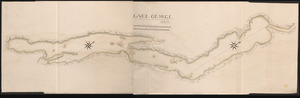
LAKE GEORGE
23.
City of Boston open space
24.
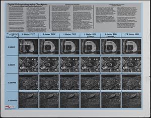
Digital orthography checkplots : a comparison of digital imagery resolution and file format
25.
Orthophoto quads index
26.
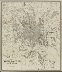
Map of greater Baltimore, compiled from official records : area 91.93 sq. mi
27.
Area plan as of May 1962
28.
The Boston Public Libraries
29.
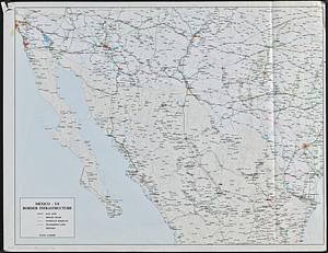
Mexico - US border infrastructure
30.
The public libraries of Massachusetts
31.
Map of city of St. Louis and suburbs
32.
Orange Harbour, Tierra del Fuego
33.
Plan of the city of New York : showing the made and swamp land
34.
Plan of Plainfield made by E. S. Darling, dated November, 1830
35.
Map of the city of Charleston, S.C. and vicinity : with table of reference to principle buildings, points of historical interest
‹ Prev
Next ›
1
2