Toggle navigation
LMEC Home
Exhibitions
Georeferencing
Tools for Teachers
Collections
My Favorites
Sign Up / Log In
Search
Search the map portal
Map Collection
Map Collection
Map Sets
Search
Search
Search for
Search In
All Fields
Creator
Title
Subject
Place
Search All Digital Collections
Advanced Search
150 Results
My Search
Start Over
1903
Remove constraint 1903
Filter your Search
Place
North and Central America
123
United States
69
Boston
36
Suffolk (county)
36
Oklahoma
10
Canada
8
Massachusetts
6
Middlesex (county)
5
more
Place
»
Topic
Boston (Mass.)--Maps
22
Landowners--Massachusetts--Boston--Maps
20
Indian reservations--Oklahoma--Maps
9
Indian Territory--Maps
7
Oklahoma--Maps
7
Boston (Mass.)--History--Colonial period, ca. 1600-1775--Maps
5
Homeowners--Massachusetts--Boston--Maps
5
Boston (Mass.)--Maps--Early works to 1800
4
more
Topic
»
Date
Date range begin
–
Date range end
Current results range from
1757
to
1999
View distribution
Creator
United States. Post Office Dept
34
Lamb, George
16
Olmsted, Frederick Law, 1822-1903
9
United States. Commission to the Five Civilized Tribes
8
Julius Bien & Co.
6
United States. Post Office Department
5
Lamb, George.
4
Norris Peters Co.
4
more
Creator
»
Format
Maps/Atlases
149
Manuscripts
2
Books
1
Objects/Artifacts
1
Georeferenced
Yes
21
No
129
Collection
Norman B. Leventhal Map Center Collection
143
Boston and New England Maps
32
Urban Maps
31
American Revolutionary War-Era Maps
5
Maritime Charts and Atlases
5
Mapping Boston Collection
2
Massachusetts Real Estate Atlases
2
American Textile History Museum Image Collection
1
more
Collection
»
Available to use
No known restrictions
143
Creative Commons license
4
Search Constraints
Sort by date (desc)
relevance
title
date (asc)
date (desc)
Number of results to display per page
20 per page
10
per page
20
per page
50
per page
100
per page
View results as:
grid view
map view
Search Results
21.
Carte générale des grandes communications télégraphiques du monde
22.
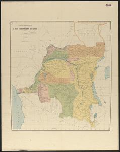
Carte politique de l'État Indépendant du Congo
23.
Center of New York, first city of the world
24.
Central part of Boston Elevated Railway system showing connections
25.
Central part of Boston Elevated Railway system showing connections 1903
26.
Charles River Basin contour map of lower basin from surveys and soundings made in Aug. and Sept. 1902 for Committee on Charles...
27.
Charles River Basin contour map of upper basin from surveys and soundings
28.
Charles River, Boston Harbor, and the proposed Charles River basin : prepared to accompany report made to Henry L. Higginson,...
29.
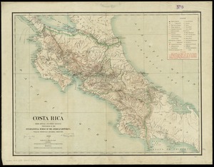
Costa Rica : from official and other sources
30.
Elihu Geer's sons' new map of Hartford from the latest surveys
31.
Gesandtschaftsviertel in Peking
32.
Gloucester, Essex County, Massachusetts : Oct. 1903
33.
Highway map of Plymouth County, Massachusetts : prepared for the Plymouth County atlas
34.
Indian Territory : progress of sub-division survey, June 30, 1902
35.
Indian Territory
36.
Indian Territory showing railroad systems - June 30, 1902
37.
Indian Territory showing townsites approved to June 30-1902
38.
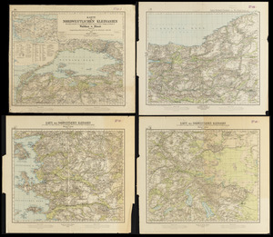
Karte des nordwestlichen Kleinasien : nach eigenen aufnahmen und unveröffentlichtem material auf Heinrich Kiepert's grundlage
39.
Lake Winnipesaukee, New Hampshire
40.
Maine Central Railroad : through the White Mountains
‹ Prev
Next ›
1
2
3
4
5
6
7
8