Toggle navigation
LMEC Home
Exhibitions
Georeferencing
Tools for Teachers
Collections
My Favorites
Sign Up / Log In
Search
Search the map portal
Map Collection
Map Collection
Map Sets
Search
Search
Search for
Search In
All Fields
Creator
Title
Subject
Place
Search All Digital Collections
Advanced Search
52 Results
My Search
Start Over
1805
Remove constraint 1805
Filter your Search
Place
North and Central America
36
United States
29
Europe
7
North America
7
Canada
5
Massachusetts
5
Boston
3
France
3
more
Place
»
Topic
Manuscript maps
6
North America--Maps--Early works to 1800
5
Northeastern States--Maps--Early works to 1800
4
United States--Maps--Early works to 1800
4
Boston (Mass.)--Maps--Early works to 1800
2
Boston Bay (Mass.)--Maps--Early works to 1800
2
Boston Harbor (Mass.)--Maps--Early works to 1800
2
Cornwallis, Charles Cornwallis, Marquis, 1738-1805
2
more
Topic
»
Date
Date range begin
–
Date range end
Current results range from
1755
to
1849
View distribution
Creator
Pownall, Thomas, 1722-1805
10
Pintado, Vicente Sebastián, 1774-1829
6
Chabert, Joseph Bernard, marquis de, 1724-1805
3
Desnos, Louis-Charles, 1725-1805
3
Evans, Lewis, 1700?-1756
3
Laurie & Whittle
3
Bowen, Thomas Bartholomew, 1742?-1805
2
Churchman, John, 1753-1805
2
more
Creator
»
Format
Maps/Atlases
51
Manuscripts
11
Objects/Artifacts
1
Georeferenced
Yes
4
No
48
Collection
American Revolutionary War-Era Maps
39
Norman B. Leventhal Map & Education Center Collection
18
Library of Congress Collection
8
MacLean Collection Map Library
6
Boston and New England Maps
5
Urban Maps
5
Maps from AAS
4
Maritime Charts and Atlases
4
more
Collection
»
Available to use
Creative Commons license
22
No known restrictions
16
Search Constraints
Sort by relevance
relevance
title
date (asc)
date (desc)
Number of results to display per page
20 per page
10
per page
20
per page
50
per page
100
per page
View results as:
grid view
map view
Search Results
21.
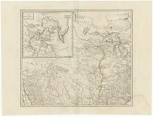
Generalkarte von Nordamerika samt den Westindischen Inseln
22.
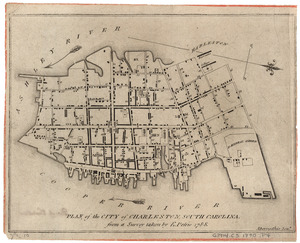
Plan of the city of Charleston, South Carolina
23.
The Windward Passage, with the several passages from the east end of Cuba : & from the north part of St. Domingo
24.
Carte des Etats-Unis d'Amérique, et du cours du Mississippi : rédigée d'après différentes cartes et relations Anglaises et...
25.
A New map of North America with the West India Islands : divided according to the preliminary articles of peace, signed at...
26.
A general map of the middle British colonies, in America : viz Virginia, Màriland, Dèlaware, Pensilvania, New-Jersey, New-York,...
27.
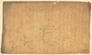
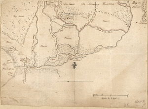
Les marches du corps du Lord Cornwallis de Billinsport jusqu'a Philadelphia au mois de Novembre, 1777
28.
Liverpool
29.
Nouveau Mexique, Louisiane, Canada, et les Etats Unis
30.
The provinces of New York, and New Jersey, : with part of Pensilvania [sic], and the province of Quebec
31.
Carte nouvelle des posséssions angloises en Amérique dressée pour l'intelligence de la guerre présente et divisée suivant les...
32.
The United States of America with the British possessions of Canada, Nova Scotia, New Brunwsick, and Newfoundland, divided with...
33.
Amerique Septentrionale divisée en ses principales parties, ou sont distingués les vns des autres les estats suivant qu'il...
34.
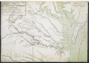
MARCH of the ARMY under Lieut:t General EARL CORNWALLIS in VIRGINIA, from the JUNCTION at Petersburg on the 20.th of May, til...
35.
Dto de Baton Rouge
36.
Map of the Rigolet and the mouth of the Pearl River, Louisiana and Mississippi
37.
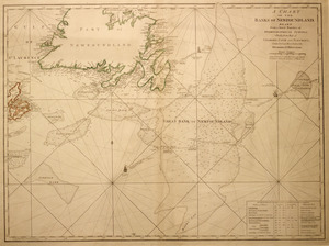
A chart of the Banks of Newfoundland
38.
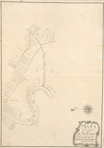
Mapa de las locaciones del Distrito de Manchack
39.
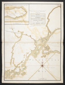
MAY 23. 1759. PROVINCE MASSACHUSETTS BAY PENOBSCOT DOMINIONS OF GREAT BRITAIN POSSESSION CONFIRM'D BY THOS. POWNALL GOVR
40.
Mapa de las locaciones del Distrito de la Na Feliciana
‹ Prev
Next ›
1
2
3