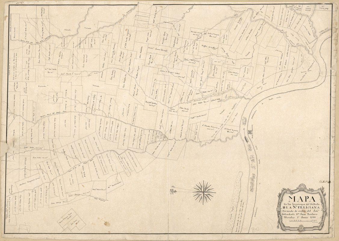
Mapa de las locaciones del Distrito de la Na Feliciana
This map is also available in American Revolutionary Geographies Online (ARGO), a collections portal especially built for material relating to the American Revolutionary War Era. Visit ARGO to learn more about this item and explore the historical geography of North America in the late eighteenth century.
Item Information
- Title:
- Mapa de las locaciones del Distrito de la Na Feliciana
- Creator:
- Pintado, Vicente Sebastián, 1774-1829
- Name on Item:
-
formado de orden del Señr Intendente Dn Juan Bentura Morales, 1o junio 1799
- Date:
-
1799
- Format:
-
Maps/Atlases
Manuscripts
- Location:
- Library of Congress Geography and Map Division
- Collection (local):
-
Library of Congress Collection
- Subjects:
-
Real property--Louisiana--West Feliciana Parish--Maps--Early works to 1800
West Feliciana Parish (La.)--Maps--Early works to 1800
Manuscript maps
- Places:
-
West Feliciana (county)
- Extent:
- 1 ms. map ; 52 x 74 cm.
- Terms of Use:
-
No known copyright restrictions.
This work is licensed for use under a Creative Commons Attribution Non-Commercial Share Alike License (CC BY-NC-SA).

- Scale:
-
Scale indeterminable
- Language:
-
Spanish
- Catalog Record:
-
https://lccn.loc.gov/2013585062
- Notes:
-
Cadastral map.
Relief shown by hachures.
Pen-and-ink.
Oriented with north to the left.
Watermarks: Budgen and fleur-de-lis in a shield surmounted by a crown over the letters GR.
From the papers of Vicente Sebastián Pintado.
Described in: Vicente Sebastián Pintado, Surveyor General of Spanish West Florida, 1805-17 : the man and his maps / by John R. Hébert. Imago mundi, v. 39, pp. 50-72. 1987. p. 70, no. 52.
In upper left margin: No 1.
In lower right corner: Plat no 4.
- Notes (citation):
-
LC Luso-Hispanic World, 947
- Identifier:
-
lh000947


![Armstrong C[ount]y](https://bpldcassets.blob.core.windows.net/derivatives/images/commonwealth:q524ng353/image_thumbnail_300.jpg)

