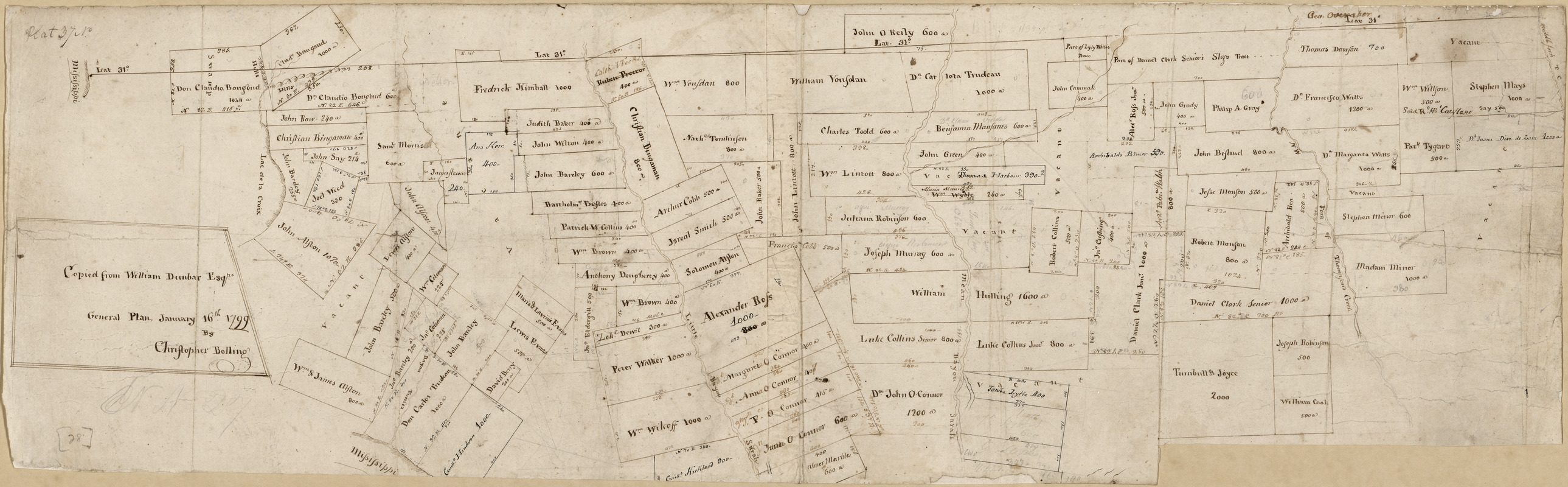
Portion of a map of Feliciana District, Spanish Louisiana, from the Lac de la Croix to Thompson's Creek
This map is also available in American Revolutionary Geographies Online (ARGO), a collections portal especially built for material relating to the American Revolutionary War Era. Visit ARGO to learn more about this item and explore the historical geography of North America in the late eighteenth century.
Item Information
- Title:
- Portion of a map of Feliciana District, Spanish Louisiana, from the Lac de la Croix to Thompson's Creek
- Creator:
- Bolling, Christopher
- Contributor:
- Pintado, Vicente Sebastián, 1774-1829
- Name on Item:
-
copied from William Dunbar, Esqr., general plan, January 16th, 1799 by Christopher Bolling
- Date:
-
[1799]
- Format:
-
Maps/Atlases
Manuscripts
- Location:
- Library of Congress Geography and Map Division
- Collection (local):
-
Library of Congress Collection
- Subjects:
-
Real property--Louisiana--West Feliciana Parish--Maps--Early works to 1800
West Feliciana Parish (La.)--Maps--Early works to 1800
Manuscript maps
- Places:
-
West Feliciana (county)
- Extent:
- 1 ms. map ; on sheet 25 x 80 cm.
- Terms of Use:
-
No known copyright restrictions.
This work is licensed for use under a Creative Commons Attribution Non-Commercial Share Alike License (CC BY-NC-SA).

- Scale:
-
Scale not given
- Language:
-
English
- Catalog Record:
-
https://lccn.loc.gov/2013585038
- Notes:
-
Shows area in West Feliciana Parish.
Cadastral map.
Relief shown by hachures and rock drawings.
Title from John R. Hébert's list of maps.
Pen-and-ink and pencil.
Has watermarks.
From the papers of Vicente Sebastián Pintado.
Described in: Vicente Sebastián Pintado, Surveyor General of Spanish West Florida, 1805-17 : the man and his maps / by John R. Hébert. Imago mundi, v. 39, pp. 50-72. 1987. p. 64, no. 28.
In upper left corner: Plat 37 no.
Sheet consists of 2 pieces pasted together.
- Notes (date):
-
This date is inferred.
- Notes (citation):
-
LC Luso-Hispanic World, 951
- Identifier:
-
lh000951


![Armstrong C[ount]y](https://bpldcassets.blob.core.windows.net/derivatives/images/commonwealth:q524ng353/image_thumbnail_300.jpg)

