Toggle navigation
LMEC Home
Exhibitions
Georeferencing
Tools for Teachers
Collections
My Favorites
Sign Up / Log In
Search
Search the map portal
Map Collection
Map Collection
Map Sets
Search
Search
Search for
Search In
All Fields
Creator
Title
Subject
Place
Search All Digital Collections
Advanced Search
237 Results
My Search
Start Over
1870
Remove constraint 1870
Filter your Search
Place
North and Central America
132
United States
114
Europe
85
Massachusetts
59
Boston
39
Germany
39
Suffolk (county)
39
France
34
more
Place
»
Topic
Franco-Prussian War, 1870-1871--Maps
33
Germany--Maps
25
Boston (Mass.)--Maps
21
Europe--Maps
17
France--Maps
17
Real property--Massachusetts--Boston--Maps
11
Land tenure--Massachusetts--Boston--Maps
8
Franco-Prussian War, 1870-1871--Aerial views
7
more
Topic
»
Date
Date range begin
–
Date range end
Current results range from
1783
to
1952
View distribution
Creator
United States. Hydrographic Office
13
Beers, F. W. (Frederick W.)
12
Hellfarth, C.
9
Justus Perthes (Firm : Gotha, Germany)
9
Petermann, A. (August), 1822-1878
8
Shurcliff, Arthur A. (Arthur Asahel), 1870-1957
8
G.W. Bacon & Co.
7
Anderson, Alexander, 1775-1870
6
more
Creator
»
Format
Maps/Atlases
233
Books
3
Manuscripts
3
Prints
2
Documents
1
Objects/Artifacts
1
Georeferenced
Yes
19
No
218
Collection
Norman B. Leventhal Map & Education Center Collection
222
Urban Maps
66
Boston and New England Maps
58
Maritime Charts and Atlases
21
American Revolutionary War-Era Maps
8
American Antiquarian Society Collection
5
Mapping Boston Collection
4
Massachusetts Real Estate Atlases
3
more
Collection
»
Available to use
No known restrictions
219
Creative Commons license
5
Search Constraints
Sort by relevance
relevance
title
date (asc)
date (desc)
Number of results to display per page
20 per page
10
per page
20
per page
50
per page
100
per page
View results as:
grid view
map view
Search Results
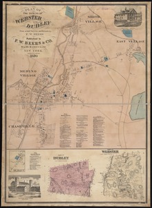
181.
Plan of the towns of Webster and Dudley : from actual surveys and records
182.
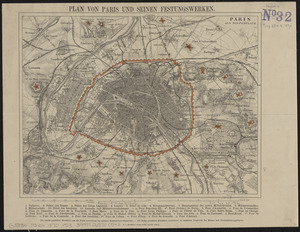
Plan von Paris und seinen festungswerken
183.
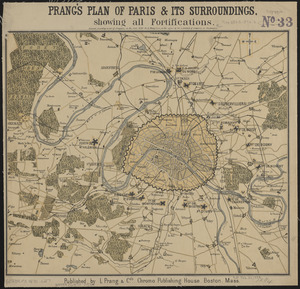
Prang's plan of Paris & its surroundings, showing all fortifications
184.
Section 16: Chemnitz
185.
Stanford's military map of the seat of war
186.
Übersichtskarte der Deutschen Nord u. Ost-see küste
187.
Wakefield, Massachusetts : diagram showing the first ten miles of the Boston & Maine Railroad
188.
Welt-karte zur übersicht der meeres-strömungen und des schnellverkehrs
189.
Plan no. 1 of building lots near Spring St. Station West Roxbury belonging to the West Roxbury Land Co
190.
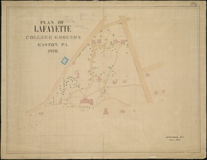
Plan of Lafayette College grounds Easton, Pa
191.
Plan of lands of Wollaston Land Associates at Wollaston Heights, Quincy
192.
Plan of the town of Dorchester
193.
Topographical map of Fairmount Park, Philadelphia : excepting Wissahickon Valley
194.
A view of part of the town of Boston in New-England and Brittish [sic] ships of war landing their troops! 1768
195.
China Sea, channel between Lamtia Island and House Hill
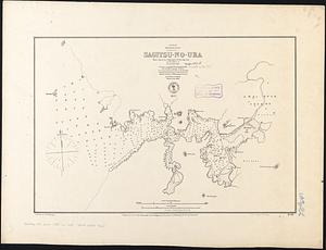
196.
Japan, Kiusiu, w. coast, Sagitsu-no-Ura : from a survey by Commander E.W. Brooker, R.N. and the officers of H.M.S. Sylvia, 1868
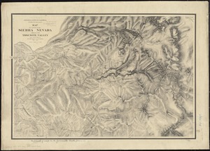
197.
Map of a portion of the Sierra Nevada adjacent to the Yosemite Valley
198.
Townsend's Patent folding globe
199.
Bedford irrigation farm
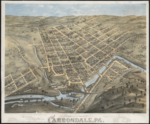
200.
Bird's eye view of Carbondale, Pa
‹ Prev
Next ›
1
2
…
6
7
8
9
10
11
12


![A view of part of the town of Boston in New-England and Brittish [sic] ships of war landing their troops! 1768](https://bpldcassets.blob.core.windows.net/derivatives/images/commonwealth:4m90f851p/image_thumbnail_300.jpg)