Toggle navigation
LMEC Home
Exhibitions
Georeferencing
Tools for Teachers
Collections
My Favorites
Sign Up / Log In
Search
Search the map portal
Map Collection
Map Collection
Map Sets
Search
Search
Search for
Search In
All Fields
Creator
Title
Subject
Place
Search All Digital Collections
Advanced Search
913 Results
My Search
Start Over
More Like
commonwealth-oai:qj72t568n
Remove constraint More Like: commonwealth-oai:qj72t568n
Filter your Search
Place
North and Central America
887
United States
627
Canada
205
New York
192
Quebec
111
Pennsylvania
60
New Jersey
54
Nova Scotia
48
more
Place
»
Topic
United States--History--Revolution, 1775-1783--Maps
305
United States--History--French and Indian War, 1754-1763--Maps
149
Saint Lawrence River--Maps
43
Newport (R.I.)--Maps
28
New York (State)--Maps
24
Hudson River (N.Y. and N.J.)--Maps
21
Québec (Québec)--Maps
21
Louisbourg (N.S.)--Maps
20
more
Topic
»
Date
Date range begin
–
Date range end
Current results range from
1700
to
1901
View distribution
Creator
Rocque, Mary Ann
29
Holland, Samuel, 1728-1801
25
Montrésor, John, 1736-1799
25
Bellin, Jacques Nicolas, 1703-1772
24
Jefferys, Thomas, -1771
24
Clinton, Henry, Sir, 1738?-1795
19
Robert Sayer and John Bennett (Firm)
15
Hills, John, active 1777-1819
13
more
Creator
»
Format
Maps/Atlases
897
Drawings/Illustrations
11
Documents
5
Objects/Artifacts
1
Prints
1
Georeferenced
Yes
1
No
912
Collection
American Revolutionary War-Era Maps
909
William L. Clements Library Collection
909
Norman B. Leventhal Map & Education Center Collection
4
Boston and New England Maps
2
Maritime Charts and Atlases
1
Available to use
No known restrictions
4
Search Constraints
Sort by relevance
relevance
title
date (asc)
date (desc)
Number of results to display per page
20 per page
10
per page
20
per page
50
per page
100
per page
View results as:
grid view
map view
Search Results
21.
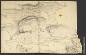
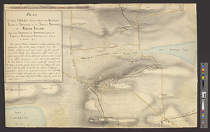
Plan of the town and environs of Newport, Rhode Island : exhibiting its defenses formed before the 8th of August 1778 when the...
22.
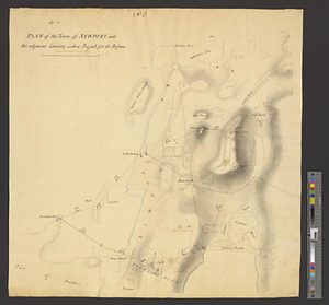
Plan of the town of Newport, and the adjacent country; with a project for its defence : (no. 7)
23.
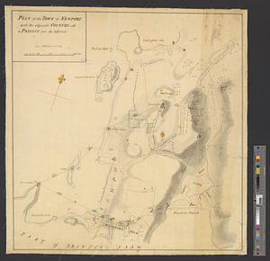
Plan of the town of Newport and the adjacent country, with a project for its defence
24.
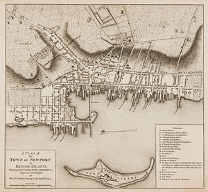
A plan of the town of Newport in Rhode Island
25.
Plan of the works, which form the exterior line of defence, for the town of New-Port in Rhode Island : also of the batteries...
26.
Providence and Newport
27.
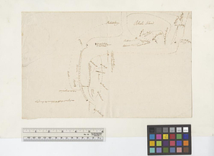
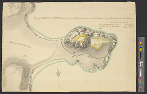
Sketch of Dumplin Point with a project for a battery of 4 guns and a redout for 90 men; with a barrack in the battery
28.
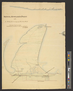
Sketch of Howland's Point with a project for its defence
29.
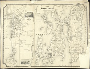
Map of Newport County, Rhode Island
30.
Chart of Narraganset Bay : surveyed in 1832
31.
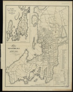
Map of Newport, R.I
32.
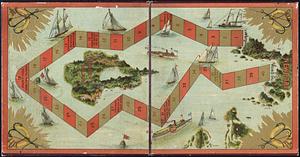
The Newport yacht race : an exciting game
33.
15 lots of 440a each in Great Lot no. 4 of Macomb purchase : 6600 acres within 2 miles of the St. Lawrence Turnpike & 1/2 mile...
34.
The above is a connection of the three surveys which I have been able to make on Peters Creek, of yours to gether with John...
35.
An accurate map of Canada, with the adjacent countries; exhibiting the late seat of war between the English & French in those...
36.
An accurate map of New York in North America from a late survey
37.
An accurate map of the British empire in Nth. America as settled by the preliminaries in 1762
38.
An accurate map of the island of St. Christophers, from an actual survey; shewing the parishes, churches; and rivers; also the...
39.
An accurate map of the West Indies : exhibiting not only all the islands possess'd by the English, French, Spaniards & Dutch...
40.
An accurate map of the West Indies, containing the Bahama & Caribbe islands the Great & Little Antilles; with the Leward and...
‹ Prev
Next ›
1
2
3
4
5
6
…
45
46