Toggle navigation
LMEC Home
Exhibitions
Georeferencing
Tools for Teachers
Collections
My Favorites
Sign Up / Log In
Search
Search the map portal
Map Collection
Map Collection
Map Sets
Search
Search
Search for
Search In
All Fields
Creator
Title
Subject
Place
Search All Digital Collections
Advanced Search
971 Results
My Search
Start Over
More Like
commonwealth-oai:q811qj27v
Remove constraint More Like: commonwealth-oai:q811qj27v
Filter your Search
Place
North and Central America
943
United States
682
New York
227
Canada
205
Quebec
111
Pennsylvania
61
New Jersey
60
Manhattan
49
more
Place
»
Topic
United States--History--Revolution, 1775-1783--Maps
330
United States--History--French and Indian War, 1754-1763--Maps
149
Manhattan (New York, N.Y.)--Maps
51
Saint Lawrence River--Maps
43
Newport (R.I.)--Maps
27
New York (N.Y.)--Maps
26
New York (State)--Maps
24
Hudson River (N.Y. and N.J.)--Maps
21
more
Topic
»
Date
Date range begin
–
Date range end
Current results range from
1700
to
1939
View distribution
Creator
Rocque, Mary Ann
29
Holland, Samuel, 1728-1801
25
Jefferys, Thomas, -1771
25
Montrésor, John, 1736-1799
25
Bellin, Jacques Nicolas, 1703-1772
24
Clinton, Henry, Sir, 1738?-1795
19
Robert Sayer and John Bennett (Firm)
16
Hills, John, active 1777-1819
13
more
Creator
»
Format
Maps/Atlases
955
Drawings/Illustrations
11
Documents
5
Manuscripts
4
Prints
1
Georeferenced
Yes
10
No
961
Collection
American Revolutionary War-Era Maps
930
William L. Clements Library Collection
909
Norman B. Leventhal Map & Education Center Collection
42
Urban Maps
26
American Antiquarian Society Collection
7
Boston and New England Maps
5
New-York Historical Society Collection
3
Newberry Library Collection
3
more
Collection
»
Available to use
No known restrictions
45
Creative Commons license
5
Search Constraints
Sort by relevance
relevance
title
date (asc)
date (desc)
Number of results to display per page
20 per page
10
per page
20
per page
50
per page
100
per page
View results as:
grid view
map view
Search Results
841.
Plan of the roads between Boston and Albany : survey'd by order of the governor in pursuance of a resolution of the General...
842.
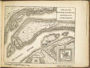
A plan of the Royal Block House, with the environs at Fort Edward
843.
A plan of the sea coast from Gage Point to Cumberland Cape including Dartmouth and Granby Bays with the coal mines in that...
844.
A plan of the settled part of Canada reduced from the large survey made in the years 1760 & 1761 by order of General Murray...
845.
A plan of the Straits of St. Mary and Michilimakinac to shew the situation & importance of the two westernmost settlements of...
846.
A plan of the survey made by, & under the direction of Augustus Porter upon the Connecticut Reserve for the Connecticut Land...
847.
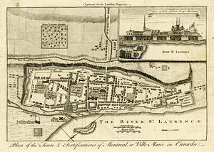
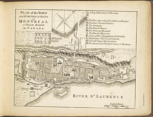
Plan of the town & fortifications of Montreal, or Ville Marie in Canada
848.
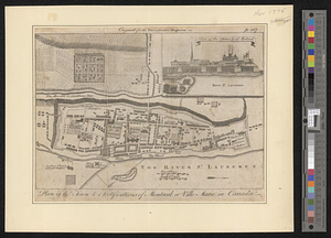
Plan of the town & fortifications of Montreal or Ville Marie in Canada
849.
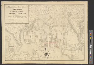
A plan of the town & port of Edenton in Chowan County, North Carolina : survey'd and drawn in 1769
850.
A plan of the town and chart of the harbour of Boston exhibiting a view of the islands castle forts and entrances into the said...
851.
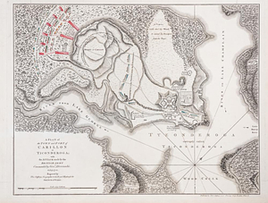
A plan of the town and fort of Carillon at Ticonderoga : with the attack made by the British army commanded by Genl....
852.
Plan of the town and fortifications of Montréal or Ville Marie in Canada
853.
Plan of the town of Boston
854.
A plan of the town of Dracut protracted by a scale of 200 rods to an inch : taken in Octobr. 1791
855.
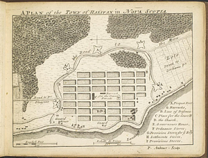
A plan of the town of Halifax in Nova Scotia
856.
A plan of the town of Halifax in Nova Scotia August 1749
857.
A plan of the town of Medford in the county of Middlesex and commonwealth of Massachusetts containing 5631 acres including...
858.
Plan of the town of Montreal
859.
A plan of the town of Newbern in Craven County, North Carolina : survey'd and drawn in 1769
860.
Plan of the town of Quebeck in Canada enlarged from Bellin's plan, with additions
‹ Prev
Next ›
1
2
…
39
40
41
42
43
44
45
46
47
48
49