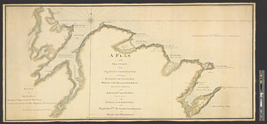
A plan of the sea coast from Gage Point to Cumberland Cape including Dartmouth and Granby Bays with the coal mines in that extent taken from the large survey of the island of Cape Britain survey'd agreable to the orders and instructions of the right honble. the Lords Commissioners of Trade and Plantations
This map is also available in American Revolutionary Geographies Online (ARGO), a collections portal especially built for material relating to the American Revolutionary War Era. Visit ARGO to learn more about this item and explore the historical geography of North America in the late eighteenth century.
Item Information
- Title:
- A plan of the sea coast from Gage Point to Cumberland Cape including Dartmouth and Granby Bays with the coal mines in that extent taken from the large survey of the island of Cape Britain survey'd agreable to the orders and instructions of the right honble. the Lords Commissioners of Trade and Plantations
- Contributor:
- Goldfrap, John George
- Creator:
- Holland, Samuel, 1728-1801
- Name on Item:
-
by Samuel Holland esqr surveyor general for the northern district of North America &c.
- Date:
-
[1767]
- Format:
-
Maps/Atlases
- Genre:
-
Manuscript maps
- Location:
- William L. Clements Library
- Collection (local):
-
William L. Clements Library Collection
- Subjects:
-
Natural resources--Nova Scotia--Maps
Cape Breton Island (N.S.)--Maps
Fort William (N.S.)--Maps
- Places:
-
CanadaNova Scotia (province)Cape Breton Island (island)
- Extent:
- 1 ms. map : col. ; 53.5 x 112 cm
- Terms of Use:
-
The University of Michigan Library provides access to these materials for educational and research purposes. These materials may be under copyright. If you decide to use any of these materials, you are responsible for making your own legal assessment and securing any necessary permission. If you have questions about the collection, please contact the William L. Clements Library.
Contact host institution for more information.
- Scale:
-
Scale 1:49,000.
- Language:
-
English
- Catalog Record:
-
Catalog record
- Notes:
-
Enclosed in: Holland to Gage, July 2, 1767.
Additional information at left of plan: Drawn for his excellency the honble. Major General Thos. Gage commander in chief of his majesty's forces in America &c by Ensn. George Goldfrap of the 60th Regt.
Identifies ruins of Fort William and various outcrops and burning mines of coal.
- Notes (date):
-
This date is inferred.
- Identifier:
-
8237
- Barcode:
-
B1938084