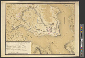
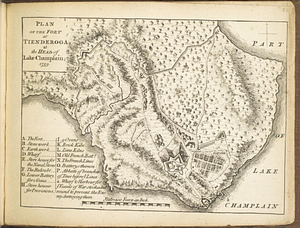
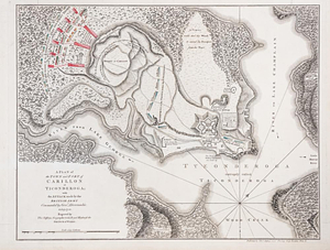
A plan of the town and fort of Carillon at Ticonderoga : with the attack made by the British army commanded by Genl. Abercrombie 8 July 1758
This map is also available in American Revolutionary Geographies Online (ARGO), a collections portal especially built for material relating to the American Revolutionary War Era. Visit ARGO to learn more about this item and explore the historical geography of North America in the late eighteenth century.
Item Information
- Title:
- A plan of the town and fort of Carillon at Ticonderoga : with the attack made by the British army commanded by Genl. Abercrombie 8 July 1758
- Creator:
- Jefferys, Thomas, -1771
- Name on Item:
-
engraved by Thos. Jefferys, Geographer to his royal highness the Prince of Wales
- Date:
-
[1768]
- Format:
-
Maps/Atlases
- Location:
- William L. Clements Library
- Collection (local):
-
William L. Clements Library Collection
- Subjects:
-
Ticonderoga (N.Y.)--Maps
Fort Ticonderoga (N.Y.)--Maps
Ticonderoga, Battle of, 1758--Maps
United States--History--French and Indian War, 1754-1763--Maps
- Places:
-
New YorkEssex (county)Ticonderoga
New YorkEssex (county)Fort Ticonderoga (transport point)
- Extent:
- 1 map : col. ; 37.2 x 48 cm.
- Terms of Use:
-
The University of Michigan Library provides access to these materials for educational and research purposes. These materials may be under copyright. If you decide to use any of these materials, you are responsible for making your own legal assessment and securing any necessary permission. If you have questions about the collection, please contact the William L. Clements Library.
Contact host institution for more information.
- Publisher:
-
London :
Published by Thos. Jefferys near Charing Cross
- Scale:
-
Scale 1:1,800.
- Language:
-
English
- Catalog Record:
-
Catalog record
- Notes:
-
Shows encampments of French troops and direction of British attacks.
Color is applied to military units only.
- Notes (date):
-
This date is inferred.
- Identifier:
-
857
- Barcode:
-
B1936318