Toggle navigation
LMEC Home
Exhibitions
Georeferencing
Tools for Teachers
Collections
My Favorites
Sign Up / Log In
Search
Search the map portal
Map Collection
Map Collection
Map Sets
Search
Search
Search for
Search In
All Fields
Creator
Title
Subject
Place
Search All Digital Collections
Advanced Search
1253 Results
My Search
Start Over
More Like
commonwealth-oai:pv63kz90b
Remove constraint More Like: commonwealth-oai:pv63kz90b
Filter your Search
Place
North and Central America
1,216
United States
956
Canada
227
New York
193
Quebec
111
Pennsylvania
61
New Jersey
57
Massachusetts
50
more
Place
»
Topic
United States--History--Revolution, 1775-1783--Maps
330
United States--Maps
330
United States--History--French and Indian War, 1754-1763--Maps
151
Saint Lawrence River--Maps
44
Elections--United States--Maps
36
Railroads--United States--Maps
34
Canada--Maps
29
Newport (R.I.)--Maps
27
more
Topic
»
Date
Date range begin
–
Date range end
Current results range from
1700
to
2023
View distribution
Creator
Paullin, Charles Oscar, 1868 or 1869-1944
70
Wright, John Kirtland, 1891-1969
70
Rocque, Mary Ann
29
Bellin, Jacques Nicolas, 1703-1772
26
Holland, Samuel, 1728-1801
25
Jefferys, Thomas, -1771
25
Montrésor, John, 1736-1799
25
Clinton, Henry, Sir, 1738?-1795
19
more
Creator
»
Format
Maps/Atlases
1,235
Drawings/Illustrations
11
Documents
5
Manuscripts
5
Prints
3
Books
1
Objects/Artifacts
1
Posters
1
Georeferenced
Yes
67
No
1,186
Collection
American Revolutionary War-Era Maps
959
William L. Clements Library Collection
909
Norman B. Leventhal Map & Education Center Collection
296
American Antiquarian Society Collection
27
MacLean Collection Map Library
11
Boston and New England Maps
5
Newberry Library Collection
3
Urban Maps
3
more
Collection
»
Available to use
No known restrictions
223
Creative Commons license
9
Search Constraints
Sort by relevance
relevance
title
date (asc)
date (desc)
Number of results to display per page
20 per page
10
per page
20
per page
50
per page
100
per page
View results as:
grid view
map view
Search Results
241.
The seat of action between the British and American forces or an authentic plan of Staten Island with the neighbouring...
242.
The seat of action, between the British and American forces or an authentic plan of the western part of Long Island, with the...
243.
Seat of war in the environs of Philadelphia
244.
Seconnet Passage
245.
Siège d'York 1781 : carte des environs d'York en Virginie avec les attaques et la position des armées Françoise et Américaine...
246.
Siege of Charleston, South Carolina 1780
247.
Siege of Charlestown 1780
248.
Siege of Yorktown
249.
Situation des posten zu Denyses Ferry auf Long Island wie solcher den 7ten October 1781 von furste : Braunshweig und Hessen...
250.
Situation of ye rebels just before the attack upon Trenton
251.
Sketch from information of the different roads about Freehold in the Jerseys
252.
Sketch from information of the different roads about Freehold in the Jerseys
253.
Sketch of different passes into Canada from our lower provinces
254.
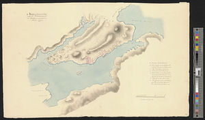
Sketch of Dumplin Point with a project for a battery of 4 guns and a redout for 90 men; with a barrack in the battery
255.
Sketch of forts Clinton and Montgomery stormed the 6th October 1777 by the troops under the command of Sr. Henry Clinton K:B:...
256.
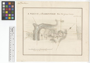
A sketch of Haddonfield : West New Jersey County
257.
A sketch of Hallifax with its environs and the works, as executed in June 1776
258.
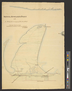
Sketch of Howland's Point with a project for its defence
259.
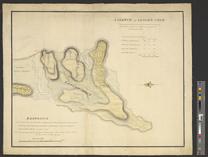
A sketch of Lloyd's Neck : particularly shewing the situation of the redoubt, encampment of the troops, with the ground...
260.
A sketch of New-London or Groton, with the attacks made on Forts Trumbull & Griswold by the British troops under the command of...
‹ Prev
Next ›
1
2
…
9
10
11
12
13
14
15
16
17
…
62
63