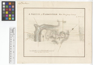
A sketch of Haddonfield : West New Jersey County
This map is also available in American Revolutionary Geographies Online (ARGO), a collections portal especially built for material relating to the American Revolutionary War Era. Visit ARGO to learn more about this item and explore the historical geography of North America in the late eighteenth century.
Item Information
- Title:
- A sketch of Haddonfield : West New Jersey County
- Contributor:
- Montrésor, John, 1736-1799
- Creator:
- Hills, John, active 1777-1819
- Name on Item:
-
by IH March 1778
- Date:
-
March 1778
- Format:
-
Maps/Atlases
- Genre:
-
Manuscript maps
- Location:
- William L. Clements Library
- Collection (local):
-
William L. Clements Library Collection
- Subjects:
-
Haddonfield (N.J.)--Maps
United States--History--Revolution, 1775-1783--Maps
- Places:
-
New JerseyCamden (county)Haddonfield
- Extent:
- 1 ms. map : col. ; 21 x 26 cm
- Terms of Use:
-
The University of Michigan Library provides access to these materials for educational and research purposes. These materials may be under copyright. If you decide to use any of these materials, you are responsible for making your own legal assessment and securing any necessary permission. If you have questions about the collection, please contact the William L. Clements Library.
Contact host institution for more information.
- Scale:
-
Scale ca. 1:14,400.
- Language:
-
English
- Catalog Record:
-
Catalog record
- Notes:
-
Finished, colored, topographical map of the town showing its buildings and roads.
Signed above neat line at left: Capt. Montresor.
Clinton Maps 244.
- Identifier:
-
584
- Barcode:
-
B1938525


