Toggle navigation
LMEC Home
Exhibitions
Georeferencing
Tools for Teachers
Collections
My Favorites
Sign Up / Log In
Search
Search the map portal
Map Collection
Map Collection
Map Sets
Search
Search
Search for
Search In
All Fields
Creator
Title
Subject
Place
Search All Digital Collections
Advanced Search
972 Results
My Search
Start Over
More Like
commonwealth-oai:kw52p6791
Remove constraint More Like: commonwealth-oai:kw52p6791
Filter your Search
Place
North and Central America
944
United States
683
New York
228
Canada
206
Quebec
112
Pennsylvania
61
New Jersey
60
Massachusetts
49
more
Place
»
Topic
United States--History--Revolution, 1775-1783--Maps
330
United States--History--French and Indian War, 1754-1763--Maps
149
New York (N.Y.)--Maps
48
Saint Lawrence River--Maps
43
Manhattan (New York, N.Y.)--Maps
30
Newport (R.I.)--Maps
27
New York (State)--Maps
26
Hudson River (N.Y. and N.J.)--Maps
22
more
Topic
»
Date
Date range begin
–
Date range end
Current results range from
1700
to
1932
View distribution
Creator
Rocque, Mary Ann
29
Holland, Samuel, 1728-1801
26
Jefferys, Thomas, -1771
25
Montrésor, John, 1736-1799
25
Bellin, Jacques Nicolas, 1703-1772
24
Clinton, Henry, Sir, 1738?-1795
19
Robert Sayer and John Bennett (Firm)
16
Kitchin, Thomas, 1719-1784
14
more
Creator
»
Format
Maps/Atlases
956
Drawings/Illustrations
11
Manuscripts
6
Documents
5
Prints
1
Georeferenced
Yes
11
No
961
Collection
American Revolutionary War-Era Maps
936
William L. Clements Library Collection
909
Norman B. Leventhal Map & Education Center Collection
37
Urban Maps
24
American Antiquarian Society Collection
11
Boston and New England Maps
5
New-York Historical Society Collection
4
MacLean Collection Map Library
3
more
Collection
»
Available to use
No known restrictions
41
Creative Commons license
5
Search Constraints
Sort by relevance
relevance
title
date (asc)
date (desc)
Number of results to display per page
20 per page
10
per page
20
per page
50
per page
100
per page
View results as:
grid view
map view
Search Results
1.
The New York campaign of 1776
2.
A plan of New York Island with the circumjacent country as far as Dobb's Ferry to the north, and White-Plains the the east;...
3.
Isle de Newyork : reconnaissance des ouvrages du nord de lisle de Newyork faite en presence des Généraux, Wasington et...
4.
Kings Bridge
5.
Part of the modern counties of Westchester and Bronx
6.
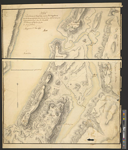
Plan des environs de Kingsbridge jusqu'au Fort Knyphausen avec les ouvrages de fortification faites dans l'année 1779 & de ceux...
7.
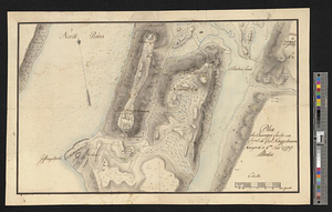
Plan des ouvrages faites en front du fort Knyphausen, New Yorck ce 4 me. Novr 1779
8.
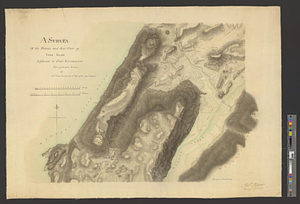
A survey of the defile and that part of York Island adjacent to Fort Knyphausen
9.
Boston Harbor, 1778
10.
Burlington, New Jersey, and Bristol, Pennsylvania
11.
Fort Lee
12.
Part of the modern counties of Union, Middlesex, and Somerset, New Jersey and Staten Island, New York
13.
Philadelphia : dedicated to his excellency Sir Henry Clinton K.B. general and commander in chief of his majesty's forces,...
14.
Plan from Paulus Hook ferry in the province of East Jersey, to King's Ferry in the province of New York and parts adjacent from...
15.
Sketch of forts Clinton and Montgomery stormed the 6th October 1777 by the troops under the command of Sr. Henry Clinton K:B:...
16.
British troop dispositions in and near New York City
17.
British troop dispositions in and near New York City, July and August 1781
18.
Plan d'operation de l'armée Angloise sous les ordres du General Howe sur Staten.-Long-&Yorck Island, depuis le mois d'Aout...
19.
The seat of action, between the British and American forces or an authentic plan of the western part of Long Island, with the...
20.
Sketch of the country illustrating the late engagement in Long Island
‹ Prev
Next ›
1
2
3
4
5
…
48
49