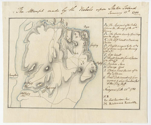
Plan d'operation de l'armée Angloise sous les ordres du General Howe sur Staten.-Long-&Yorck Island, depuis le mois d'Aout jusqu'au 16me Novembre 1776
This map is also available in American Revolutionary Geographies Online (ARGO), a collections portal especially built for material relating to the American Revolutionary War Era. Visit ARGO to learn more about this item and explore the historical geography of North America in the late eighteenth century.
Item Information
- Title:
- Plan d'operation de l'armée Angloise sous les ordres du General Howe sur Staten.-Long-&Yorck Island, depuis le mois d'Aout jusqu'au 16me Novembre 1776
- Creator:
- Martin, Reinhard Jacob
- Name on Item:
-
Martin, capitaine du corps du genie
- Date:
-
April 6, 1779
- Format:
-
Maps/Atlases
- Genre:
-
Manuscript maps
- Location:
- William L. Clements Library
- Collection (local):
-
William L. Clements Library Collection
- Subjects:
-
Staten Island (New York, N.Y.)--Maps
New York (N.Y.)--Maps
United States--History--Revolution, 1775-1783--Maps
- Places:
-
New YorkRichmond (county)Staten Island (island)
New YorkNew York
- Extent:
- 1 ms. map : col. ; 111.7 x 53.5 cm.
- Terms of Use:
-
The University of Michigan Library provides access to these materials for educational and research purposes. These materials may be under copyright. If you decide to use any of these materials, you are responsible for making your own legal assessment and securing any necessary permission. If you have questions about the collection, please contact the William L. Clements Library.
Contact host institution for more information.
- Scale:
-
Scale ca. 1:47,520.
- Language:
-
French
- Catalog Record:
-
Catalog record
- Notes:
-
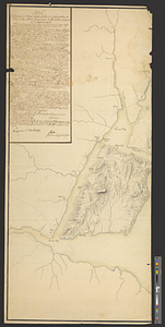
Left-hand section of a finished, colored, topographical map, which includes Staten Island and the New Jersey shoreline from Raritan Bay to Hackensack.
The right or Manhattan side of the map is missing.
A long explanation at upper left gives lettered references to the entire map.
British and German troop positions are indicated.
- Identifier:
-
8394
- Barcode:
-
B2819642