Toggle navigation
LMEC Home
Exhibitions
Georeferencing
Tools for Teachers
Collections
My Favorites
Sign Up / Log In
Search
Search the map portal
Map Collection
Map Collection
Map Sets
Search
Search
Search for
Search In
All Fields
Creator
Title
Subject
Place
Search All Digital Collections
Advanced Search
1055 Results
My Search
Start Over
More Like
commonwealth-oai:kp78mc90b
Remove constraint More Like: commonwealth-oai:kp78mc90b
Filter your Search
Place
North and Central America
1,027
United States
745
New York
251
Canada
220
Quebec
118
Pennsylvania
69
Maine
66
New Jersey
65
more
Place
»
Topic
United States--History--Revolution, 1775-1783--Maps
330
United States--History--French and Indian War, 1754-1763--Maps
150
New York (State)--Maps
85
Maine--Maps
55
Saint Lawrence River--Maps
44
New England--Maps
28
Newport (R.I.)--Maps
27
Pennsylvania--Maps
27
more
Topic
»
Date
Date range begin
–
Date range end
Current results range from
1700
to
1983
View distribution
Creator
Rocque, Mary Ann
29
Holland, Samuel, 1728-1801
27
Montrésor, John, 1736-1799
26
Bellin, Jacques Nicolas, 1703-1772
25
Jefferys, Thomas, -1771
25
Clinton, Henry, Sir, 1738?-1795
19
Robert Sayer and John Bennett (Firm)
17
Hills, John, active 1777-1819
13
more
Creator
»
Format
Maps/Atlases
1,039
Drawings/Illustrations
11
Manuscripts
9
Documents
5
Objects/Artifacts
1
Prints
1
Georeferenced
Yes
12
No
1,043
Collection
American Revolutionary War-Era Maps
960
William L. Clements Library Collection
909
Norman B. Leventhal Map & Education Center Collection
96
Boston and New England Maps
50
American Antiquarian Society Collection
24
MacLean Collection Map Library
10
Applied Geographics, Inc. Records
4
Library and Archives Canada Collection
4
more
Collection
»
Available to use
No known restrictions
99
Creative Commons license
5
Search Constraints
Sort by relevance
relevance
title
date (asc)
date (desc)
Number of results to display per page
20 per page
10
per page
20
per page
50
per page
100
per page
View results as:
grid view
map view
Search Results
841.
Plan of Fort Lernoult and the town of Detroit
842.
A plan of Fort Ligonier done by Theodosius McDonald for George Morton : February 8th annoque domini 1760
843.
Plan of Fort Massachusetts - Rocklanding - 1792
844.
Plan of Fort Massachusetts in Georgia and the country adjacent - 1792
845.
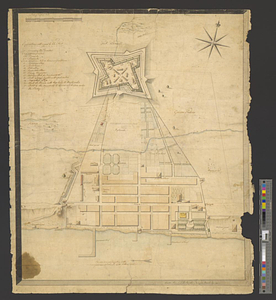
Plan of Fort Niagara, with its environ
846.
A plan of Fort Ontario
847.
Plan of Fort Ontario built at Oswego in 1759
848.
Plan of Fort Stanwix, built at Oneida Station, by provincial troops, in 1758
849.
A plan of Fort William Henry and the English camps & retrenchments with the French different camps and attack there upon
850.
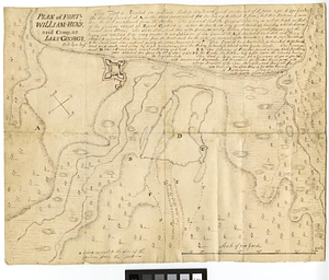
Plan of Fort-William-Henry and camp, at Lake George
851.
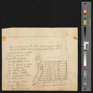
Plan of lands in the Ohio Companys purchase lying in sections no 1 & no 7 town no 2 range no 12
852.
Plan of Long Island in New York governement [sic] Nort [sic] America
853.
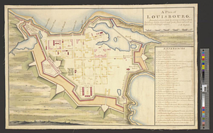
A plan of Louisbourg : intended only to shew by strong red the publick buildings lately erected; and by the faint red such as...
854.
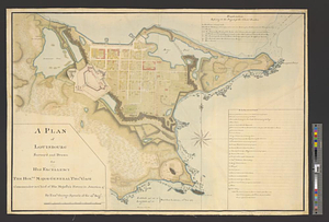
A plan of Louisbourg survey'd and drawn for his excellency the honble. Major General Thos. Gage commander in chief of his...
855.
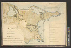
A plan of Louisbourg survey'd and drawn for his excellency the honble. Major General Thos. Gage commander in chief of his...
856.
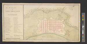
A plan of New Orleans
857.
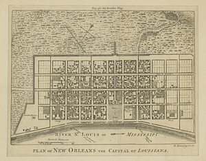
Plan of New Orleans the capital of Louisiana
858.
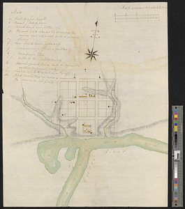
Plan of Niagara
859.
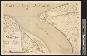
Plan of Niagara River between the Lakes Ontario and Erie
860.
Plan of part of Fort George, with the barracks &c. erected in the year 1759 : situated lat. 4 30' long. 73 30'
‹ Prev
Next ›
1
2
…
39
40
41
42
43
44
45
46
47
…
52
53


![Plan of Long Island in New York governement [sic] Nort [sic] America](https://bpldcassets.blob.core.windows.net/derivatives/metadata/commonwealth-oai:z890ws44r/image_thumbnail_300.jpg)