Toggle navigation
LMEC Home
Exhibitions
Georeferencing
Tools for Teachers
Collections
My Favorites
Sign Up / Log In
Search
Search the map portal
Map Collection
Map Collection
Map Sets
Search
Search
Search for
Search In
All Fields
Creator
Title
Subject
Place
Search All Digital Collections
Advanced Search
1012 Results
My Search
Start Over
More Like
commonwealth-oai:gx41rh29r
Remove constraint More Like: commonwealth-oai:gx41rh29r
Filter your Search
Place
North and Central America
984
United States
722
Canada
206
New York
201
Quebec
112
Pennsylvania
90
New Jersey
80
Virginia
51
more
Place
»
Topic
United States--History--Revolution, 1775-1783--Maps
330
United States--History--French and Indian War, 1754-1763--Maps
149
Pennsylvania--Maps
50
Saint Lawrence River--Maps
43
New Jersey--Maps
40
Maryland--Maps
37
New York (State)--Maps
34
Newport (R.I.)--Maps
27
more
Topic
»
Date
Date range begin
–
Date range end
Current results range from
1700
to
1931
View distribution
Creator
Rocque, Mary Ann
29
Bellin, Jacques Nicolas, 1703-1772
26
Holland, Samuel, 1728-1801
26
Jefferys, Thomas, -1771
25
Montrésor, John, 1736-1799
25
Clinton, Henry, Sir, 1738?-1795
19
Robert Sayer and John Bennett (Firm)
16
Hills, John, active 1777-1819
13
more
Creator
»
Format
Maps/Atlases
996
Drawings/Illustrations
11
Documents
5
Manuscripts
5
Prints
1
Georeferenced
Yes
32
No
980
Collection
American Revolutionary War-Era Maps
947
William L. Clements Library Collection
909
Norman B. Leventhal Map & Education Center Collection
71
Maps from AAS
16
MacLean Collection Map Library
6
Boston and New England Maps
5
Urban Maps
5
Newberry Library Collection
3
more
Collection
»
Available to use
No known restrictions
73
Creative Commons license
5
Search Constraints
Sort by relevance
relevance
title
date (asc)
date (desc)
Number of results to display per page
20 per page
10
per page
20
per page
50
per page
100
per page
View results as:
grid view
map view
Search Results
421.
The above is a connection of the three surveys which I have been able to make on Peters Creek, of yours to gether with John...
422.
An accurate map of Canada, with the adjacent countries; exhibiting the late seat of war between the English & French in those...
423.
An accurate map of New York in North America from a late survey
424.
An accurate map of the British empire in Nth. America as settled by the preliminaries in 1762
425.
An accurate map of the island of St. Christophers, from an actual survey; shewing the parishes, churches; and rivers; also the...
426.
An accurate map of the West Indies : exhibiting not only all the islands possess'd by the English, French, Spaniards & Dutch...
427.
An accurate map of the West Indies, containing the Bahama & Caribbe islands the Great & Little Antilles; with the Leward and...
428.
Action between Genl. St Clairs army & that of the American Indians Novr. 4th 1791 : collected from his public letter
429.
Admiral George Clinton's lands in the "Oblong"
430.
Albemarle and Pamlico Sounds
431.
Allegheny River and French Creek
432.
America, engraved according to recent geographical observations
433.
L'Amérique, divisée par grands etats
434.
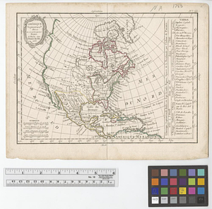
L'Amérique Septentrionale
435.
Amérique Septentrionale divisée en ses principaux etats
436.
Attaques des forts de Chouaguen en Amérique pris par les français commandés par le Marquis de Montcalm le 14 Août 1756
437.
Attaques des retranchemens devant le fort Carillon en Amérique par les anglais commandés par le général Abercrombie contre les...
438.
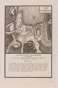
Attaques du fort William-Henri en Amérique par les troupes français aux ordres du Marquis de Montcalm prise de ce fort le 7...
439.
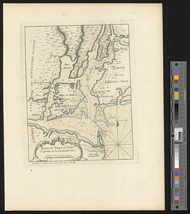
Baye et port d'Yorc capitale de la Nouvelle Yorc
440.
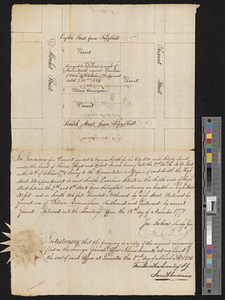
Block between Sixteenth and Seventeenth Streets and Chestnut and Market Streets, Philadelphia, 1771
‹ Prev
Next ›
1
2
…
18
19
20
21
22
23
24
25
26
…
50
51