Toggle navigation
LMEC Home
Exhibitions
Georeferencing
Tools for Teachers
Collections
My Favorites
Sign Up / Log In
Search
Search the map portal
Map Collection
Map Collection
Map Sets
Search
Search
Search for
Search In
All Fields
Creator
Title
Subject
Place
Search All Digital Collections
Advanced Search
946 Results
My Search
Start Over
More Like
commonwealth-oai:c534kn48m
Remove constraint More Like: commonwealth-oai:c534kn48m
Filter your Search
Place
North and Central America
910
United States
629
Canada
220
New York
194
Quebec
121
Saint Lawrence River
66
Pennsylvania
60
New Jersey
54
more
Place
»
Topic
United States--History--Revolution, 1775-1783--Maps
305
United States--History--French and Indian War, 1754-1763--Maps
149
Saint Lawrence River--Maps
67
Newport (R.I.)--Maps
27
New York (State)--Maps
24
Québec (Québec)--Maps
24
Hudson River (N.Y. and N.J.)--Maps
21
Louisbourg (N.S.)--Maps
20
more
Topic
»
Date
Date range begin
–
Date range end
Current results range from
1700
to
1923
View distribution
Creator
Montrésor, John, 1736-1799
29
Rocque, Mary Ann
29
Bellin, Jacques Nicolas, 1703-1772
28
Holland, Samuel, 1728-1801
28
Jefferys, Thomas, -1771
26
Clinton, Henry, Sir, 1738?-1795
19
Robert Sayer and John Bennett (Firm)
17
Cook, James, 1728-1779
13
more
Creator
»
Format
Maps/Atlases
930
Drawings/Illustrations
11
Documents
5
Manuscripts
1
Prints
1
Georeferenced
No
946
Collection
American Revolutionary War-Era Maps
934
William L. Clements Library Collection
909
Library and Archives Canada Collection
17
Norman B. Leventhal Map & Education Center Collection
12
MacLean Collection Map Library
3
New York Public Library Collection
3
Maps from AAS
2
Boston and New England Maps
1
Available to use
No known restrictions
12
Creative Commons license
3
Search Constraints
Sort by relevance
relevance
title
date (asc)
date (desc)
Number of results to display per page
20 per page
10
per page
20
per page
50
per page
100
per page
View results as:
grid view
map view
Search Results
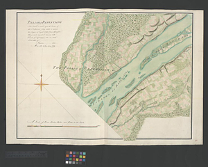
41.
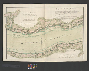
Parish of Repentigny
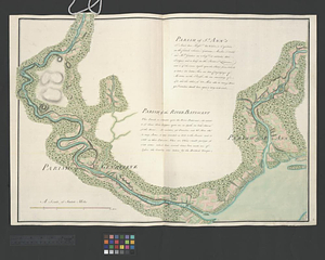
42.
Parish of St. Ann's. Parish of the River Batiscant
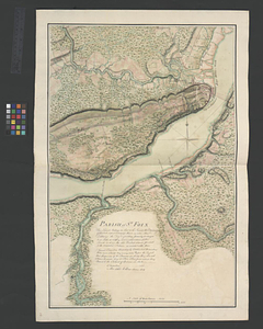
43.
Parish of St. Foix
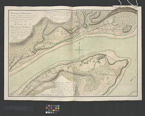
44.
Parish of St. Joachim. Parish of St. Famille. Parish of St. Anne. Parish of St. François
45.
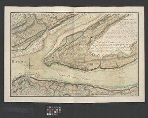
Parish of St. Lawrence. Parish of Beaumont. Parish of St. Peter
46.
Parish of St. Michelle. Parish of St. John Baptist. Parish of St. Vertier
47.
Parish of St. Nicholas. The Parish of St. Augustin
48.
Parish of the Ecureuils. Parish of Point aux Trembles. Parish of St. Antoine. Parish of St. Croix
49.
Part of the Anticosti Island; Mingan Island; Mignan Harbor
50.
A plan of part of the province of Quebec from the river St. Anne to the island of Coudre made agreeable to the orders and...
51.
A plan of the river St. Laurence, from Sillery to the fall of Montmerenci, with the operations of the siege of Quebec; under...
52.
Region of Gaspee Bay
53.
Region of Hare Island
54.
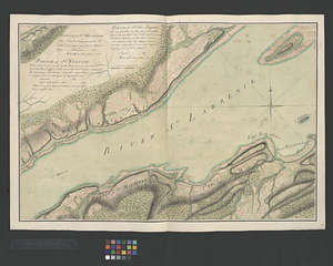
The River St. Lawrence from Mal Bay to the Basin of Quebec
55.
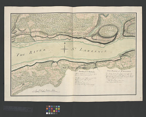
The River St. Lawrence from the Basin of Quebec to the Falls of Richeu
56.
The Seven Islands and the Bay
57.
The Shoals of Beauport; The River St. Lawrence from the Basin of Quebec to the Falls of Richeu
58.
The St. Lawrence River between Trois Rivières and Grondines Parish
59.
The St. Lawrence River from the Rapids of Richelieu to Cape Torment
60.
St. Paul's Bay; Isle de Coudres; Great Cove; Pt. de Mille Vaches
‹ Prev
Next ›
1
2
3
4
5
6
7
…
47
48