Toggle navigation
LMEC Home
Exhibitions
Georeferencing
Tools for Teachers
Collections
My Favorites
Sign Up / Log In
Search
Search the map portal
Map Collection
Map Collection
Map Sets
Search
Search
Search for
Search In
All Fields
Creator
Title
Subject
Place
Search All Digital Collections
Advanced Search
1000 Results
My Search
Start Over
More Like
commonwealth-oai:b2777s68s
Remove constraint More Like: commonwealth-oai:b2777s68s
Filter your Search
Place
North and Central America
972
United States
710
Canada
206
New York
201
Quebec
112
Pennsylvania
91
New Jersey
80
Massachusetts
50
more
Place
»
Topic
United States--History--Revolution, 1775-1783--Maps
330
United States--History--French and Indian War, 1754-1763--Maps
149
Pennsylvania--Maps
50
Saint Lawrence River--Maps
43
New Jersey--Maps
40
New York (State)--Maps
34
Newport (R.I.)--Maps
27
Maryland--Maps
25
more
Topic
»
Date
Date range begin
–
Date range end
Current results range from
1700
to
1921
View distribution
Creator
Rocque, Mary Ann
29
Holland, Samuel, 1728-1801
26
Bellin, Jacques Nicolas, 1703-1772
25
Jefferys, Thomas, -1771
25
Montrésor, John, 1736-1799
25
Clinton, Henry, Sir, 1738?-1795
19
Robert Sayer and John Bennett (Firm)
16
Kitchin, Thomas, 1719-1784
13
more
Creator
»
Format
Maps/Atlases
984
Drawings/Illustrations
11
Documents
5
Manuscripts
5
Prints
1
Georeferenced
Yes
27
No
973
Collection
American Revolutionary War-Era Maps
945
William L. Clements Library Collection
909
Norman B. Leventhal Map & Education Center Collection
60
Maps from AAS
15
MacLean Collection Map Library
6
Boston and New England Maps
5
Urban Maps
5
Newberry Library Collection
3
more
Collection
»
Available to use
No known restrictions
62
Creative Commons license
5
Search Constraints
Sort by relevance
relevance
title
date (asc)
date (desc)
Number of results to display per page
20 per page
10
per page
20
per page
50
per page
100
per page
View results as:
grid view
map view
Search Results
181.
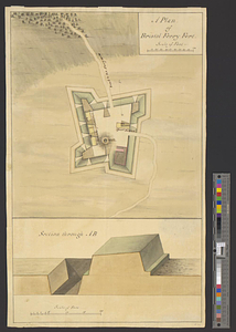
A plan of Bristol Ferry fort
182.
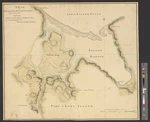
A plan of Brookhaven or Setalket Harbour with its environs
183.
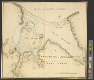
Plan of Brookhaven, or Setalket on Long Island
184.
Plan of Charleston and its defenses 1780
185.
Plan of Charlestown 1781
186.
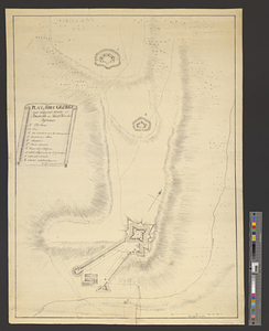
Plan of Fort Brown, for 4 guns en barbette; with a small redout, and a line for 60 men, and a barrack
187.
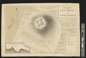
Plan of Fort Edward in Nova Scotia
188.
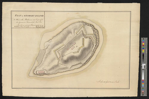
Plan of Fort George and adjacent works at Pensacola in West Florida
189.
Plan of Georges Island : NB where the platforms are expres'd the guns are mounted but the merlons are not repaired
190.
Plan of ground about Wilmington
191.
Plan of Isle aux Noix at the north end of Lake Champlain 1780
192.
A plan of Manchac 1774
193.
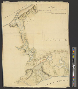
Plan of Merritck [sic] in the township of Southold on Long Island
194.
A plan of Merritick in the township of Southold on Long Island
195.
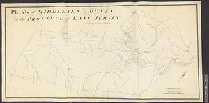
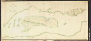
Plan of Middlesex County in the province of East Jersey : copied from the original by Lieut. I. Hills, asst. engr.
196.
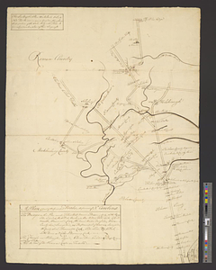
A plan of New York Island with the circumjacent country as far as Dobb's Ferry to the north, and White-Plains the the east;...
197.
A plan of part of the principal roads in the province of No. Carolina
198.
Plan of part of the province of Virginia
199.
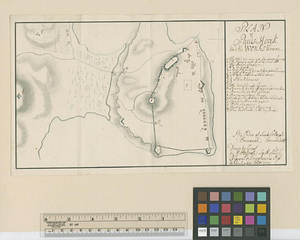
Plan of Pauls-Hoock and the works thereon : by ordre of Lieut. Collonel Emmerick commandant
200.
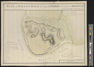
Plan of Paulus Hook shewing the works erected for its defence
‹ Prev
Next ›
1
2
…
6
7
8
9
10
11
12
13
14
…
49
50


![Plan of Merritck [sic] in the township of Southold on Long Island](https://bpldcassets.blob.core.windows.net/derivatives/metadata/commonwealth-oai:8623ns35f/image_thumbnail_300.jpg)