Toggle navigation
LMEC Home
Exhibitions
Georeferencing
Tools for Teachers
Collections
My Favorites
Sign Up / Log In
Search
Search the map portal
Map Collection
Map Collection
Map Sets
Search
Search
Search for
Search In
All Fields
Creator
Title
Subject
Place
Search All Digital Collections
Advanced Search
1021 Results
My Search
Start Over
More Like
commonwealth-oai:9306xx619
Remove constraint More Like: commonwealth-oai:9306xx619
Filter your Search
Place
North and Central America
993
United States
725
New York
253
Canada
208
Quebec
112
New Jersey
80
Pennsylvania
71
Massachusetts
49
more
Place
»
Topic
United States--History--Revolution, 1775-1783--Maps
330
United States--History--French and Indian War, 1754-1763--Maps
150
New York (State)--Maps
85
Saint Lawrence River--Maps
43
New Jersey--Maps
40
Pennsylvania--Maps
29
Newport (R.I.)--Maps
27
Hudson River (N.Y. and N.J.)--Maps
23
more
Topic
»
Date
Date range begin
–
Date range end
Current results range from
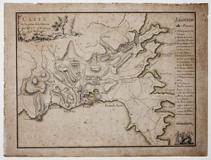
1700
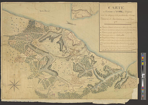
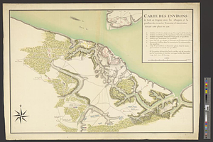
to
1976
View distribution
Creator
Rocque, Mary Ann
29
Holland, Samuel, 1728-1801
26
Bellin, Jacques Nicolas, 1703-1772
25
Jefferys, Thomas, -1771
25
Montrésor, John, 1736-1799
25
Clinton, Henry, Sir, 1738?-1795
18
Robert Sayer and John Bennett (Firm)
16
Hills, John, active 1777-1819
13
more
Creator
»
Format
Maps/Atlases
1,005
Manuscripts
12
Drawings/Illustrations
11
Documents
5
Prints
1
Georeferenced
Yes
21
No
1,000
Collection
American Revolutionary War-Era Maps
955
William L. Clements Library Collection
909
Norman B. Leventhal Map & Education Center Collection
70
Boston and New England Maps
18
American Antiquarian Society Collection
17
New-York Historical Society Collection
9
MacLean Collection Map Library
7
Newberry Library Collection
3
more
Collection
»
Available to use
No known restrictions
79
Creative Commons license
6
Search Constraints
Sort by relevance
relevance
title
date (asc)
date (desc)
Number of results to display per page
20 per page
10
per page
20
per page
50
per page
100
per page
View results as:
grid view
map view
Search Results
61.
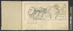
Battle of Monmouth, 28th June 1778
62.
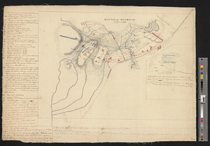
Battle of Monmouth, 28th June 1778
63.
Bedford
64.
Bedford &c.
65.
Blackwell's Island
66.
Boston
67.
Boston Harbor
68.
Boston Harbor, 1778
69.
British capture of Savannah
70.
British troop dispositions in and near New York City
71.
British troop dispositions in and near New York City, July and August 1781
72.
British troop dispositions in and near New York City, Sept. 2d 1781
73.
The British works at Yorktown and Gloucester
74.
Burlington, New Jersey, and Bristol, Pennsylvania
75.
Cambridge to Prospect Hill
76.
Carte de la prise de la Grenade par Mr. Cmte. d'Estaing, le 5 juillet 1779
77.
Carte des environs de York en Virginie avec les attaques et la position des armées Françoise et Américaine, devant cette place...
78.
Carte des environs de York en Virginie avec les attaques et la position des armées Françoise et Américaine devant cette place...
79.
Charles Town, South Carolina, with a chart of the bars & harbour
80.
Charleston and its approaches from the sea
‹ Prev
Next ›
1
2
3
4
5
6
7
8
…
51
52