Toggle navigation
LMEC Home
Exhibitions
Georeferencing
Tools for Teachers
Collections
My Favorites
Sign Up / Log In
Search
Search the map portal
Map Collection
Map Collection
Map Sets
Search
Search
Search for
Search In
All Fields
Creator
Title
Subject
Place
Search All Digital Collections
Advanced Search
944 Results
My Search
Start Over
More Like
commonwealth-oai:9306xx555
Remove constraint More Like: commonwealth-oai:9306xx555
Filter your Search
Place
North and Central America
916
United States
656
Canada
206
New York
198
Quebec
112
Pennsylvania
60
New Jersey
58
Massachusetts
50
more
Place
»
Topic
United States--History--Revolution, 1775-1783--Maps
330
United States--History--French and Indian War, 1754-1763--Maps
149
Saint Lawrence River--Maps
43
Hudson River (N.Y. and N.J.)--Maps
29
Newport (R.I.)--Maps
27
New York (State)--Maps
26
Québec (Québec)--Maps
21
Louisbourg (N.S.)--Maps
20
more
Topic
»
Date
Date range begin
–
Date range end
Current results range from
1700
to
1912
View distribution
Creator
Rocque, Mary Ann
29
Holland, Samuel, 1728-1801
26
Jefferys, Thomas, -1771
25
Montrésor, John, 1736-1799
25
Bellin, Jacques Nicolas, 1703-1772
24
Clinton, Henry, Sir, 1738?-1795
18
Robert Sayer and John Bennett (Firm)
16
Hills, John, active 1777-1819
13
more
Creator
»
Format
Maps/Atlases
928
Drawings/Illustrations
11
Documents
5
Manuscripts
4
Prints
1
Georeferenced
Yes
2
No
942
Collection
American Revolutionary War-Era Maps
930
William L. Clements Library Collection
909
Norman B. Leventhal Map & Education Center Collection
16
Maps from AAS
8
Boston and New England Maps
5
Newberry Library Collection
3
Urban Maps
3
MacLean Collection Map Library
2
more
Collection
»
Available to use
No known restrictions
18
Creative Commons license
4
Search Constraints
Sort by relevance
relevance
title
date (asc)
date (desc)
Number of results to display per page
20 per page
10
per page
20
per page
50
per page
100
per page
View results as:
grid view
map view
Search Results
1.
Hudson River from Stony Point to West Point
2.
Plan des environs de West Point jusqu'au Croton River... : Morrishous ce 14me Juin 1779
3.
West Point; or Fort Defiance
4.
Forts of the Highlands, ca. 1777
5.
Sketch of forts Clinton and Montgomery stormed the 6th October 1777 by the troops under the command of Sr. Henry Clinton K:B:...
6.
Distances North River
7.
Hudson River from Anthony's Nose to Stony Point
8.
Hudson River from Peekskill to Slaughters Landing
9.
Hudson River from West Point to Dobbs Ferry
10.
Lent's Creek and Baillies Creek
11.
Moore's sketch of the navigation of the Highlands
12.
Part of the modern counties of Dutchess, Putnam, and Westchester
13.
The seat of action between the British and American forces or an authentic plan of Staten Island with the neighbouring...
14.
The seat of action, between the British and American forces or an authentic plan of the western part of Long Island, with the...
15.
Valley of the Hudson River from Fishkill to Teller's Point
16.
Verplanks
17.
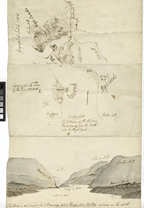
Geographick scetch [sic], 1754
18.
Hudson River highlands at Martelaers Rock
19.
Hudson's River from New York to Albany
20.
Map from Albany to Crown Point
‹ Prev
Next ›
1
2
3
4
5
…
47
48


![Geographick scetch [sic], 1754](https://bpldcassets.blob.core.windows.net/derivatives/metadata/commonwealth-oai:pk02h894n/image_thumbnail_300.jpg)