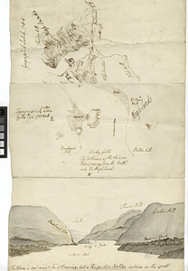
Moore's sketch of the navigation of the Highlands

This map is also available in American Revolutionary Geographies Online (ARGO), a collections portal especially built for material relating to the American Revolutionary War Era. Visit ARGO to learn more about this item and explore the historical geography of North America in the late eighteenth century.
Item Information
- Title:
- Moore's sketch of the navigation of the Highlands
- Date:
-
[1770–1779]
- Format:
-
Maps/Atlases
- Genre:
-
Manuscript maps
- Location:
- William L. Clements Library
- Collection (local):
-
William L. Clements Library Collection
- Subjects:
-
Hudson Highlands (N.Y.)--Maps
Hudson River (N.Y. and N.J.)--Maps
United States--History--Revolution, 1775-1783--Maps
- Places:
-
Hudson River
- Extent:
- 1 ms. map : outline col. ; 30.1 x 38 cm
- Terms of Use:
-
The University of Michigan Library provides access to these materials for educational and research purposes. These materials may be under copyright. If you decide to use any of these materials, you are responsible for making your own legal assessment and securing any necessary permission. If you have questions about the collection, please contact the William L. Clements Library.
Contact host institution for more information.
- Scale:
-
Scale [ca. 1:63,360].
- Language:
-
English
- Catalog Record:
-
Catalog record
- Notes:
-
Title from verso.
Colored topographical sketch map showing Hudson River from Haverstraw Bay to Fort Constitution.
"Moore" in the title probably refers to the Moore whose house is shown at the site of West Point.
Note in the folder suggests that map dates to 1776.
Clinton Maps 167.
- Notes (date):
-
This date is inferred.
- Identifier:
-
532
- Barcode:
-
B1936408


![Geographick scetch [sic], 1754](https://bpldcassets.blob.core.windows.net/derivatives/metadata/commonwealth-oai:pk02h894n/image_thumbnail_300.jpg)