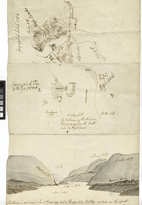
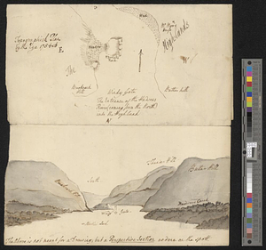
Geographick scetch [sic], 1754
![Geographick scetch [sic], 1754](https://bpldcassets.blob.core.windows.net/derivatives/metadata/commonwealth-oai:pk02h894n/image_thumbnail_300.jpg)
This map is also available in American Revolutionary Geographies Online (ARGO), a collections portal especially built for material relating to the American Revolutionary War Era. Visit ARGO to learn more about this item and explore the historical geography of North America in the late eighteenth century.
Item Information
- Title:
- Geographick scetch [sic], 1754
- Title (alt.):
-
Geographic sketch, 1754
- Date:
-
1754
- Format:
-
Maps/Atlases
- Genre:
-
Manuscript maps
- Location:
- William L. Clements Library
- Collection (local):
-
William L. Clements Library Collection
- Subjects:
-
West Point (N.Y.)--Maps
Hudson Highlands (N.Y.)--Maps
Hudson River (N.Y. and N.J.)--Maps
- Places:
-
New YorkOrange (county)West Point
Hudson River
- Extent:
- 1 ms. map ; 28.5 x 15 cm
- Terms of Use:
-
The University of Michigan Library provides access to these materials for educational and research purposes. These materials may be under copyright. If you decide to use any of these materials, you are responsible for making your own legal assessment and securing any necessary permission. If you have questions about the collection, please contact the William L. Clements Library.
Contact host institution for more information.
- Scale:
-
Scale indeterminable.
- Language:
-
English
- Catalog Record:
-
Catalog record
- Notes:
-
On same sheet as Topographick plan by the eye, 1754 & 6 and [Hudson River Highlands at Martelaers Rock].
- Identifier:
-
5526
- Barcode:
-
B1936533