Toggle navigation
LMEC Home
Exhibitions
Georeferencing
Tools for Teachers
Collections
My Favorites
Sign Up / Log In
Search
Search the map portal
Map Collection
Map Collection
Map Sets
Search
Search
Search for
Search In
All Fields
Creator
Title
Subject
Place
Search All Digital Collections
Advanced Search
967 Results
My Search
Start Over
More Like
commonwealth-oai:7h14fn780
Remove constraint More Like: commonwealth-oai:7h14fn780
Filter your Search
Place
North and Central America
941
United States
677
New York
247
Canada
208
Quebec
112
Pennsylvania
69
New Jersey
61
Nova Scotia
48
more
Place
»
Topic
United States--History--Revolution, 1775-1783--Maps
305
United States--History--French and Indian War, 1754-1763--Maps
150
New York (State)--Maps
81
Saint Lawrence River--Maps
43
Newport (R.I.)--Maps
27
Pennsylvania--Maps
27
Hudson River (N.Y. and N.J.)--Maps
23
New England--Maps
21
more
Topic
»
Date
Date range begin
–
Date range end
Current results range from
1700
to
1976
View distribution
Creator
Rocque, Mary Ann
29
Holland, Samuel, 1728-1801
26
Bellin, Jacques Nicolas, 1703-1772
25
Montrésor, John, 1736-1799
25
Jefferys, Thomas, -1771
24
Clinton, Henry, Sir, 1738?-1795
19
Robert Sayer and John Bennett (Firm)
15
Hills, John, active 1777-1819
13
more
Creator
»
Format
Maps/Atlases
951
Drawings/Illustrations
11
Documents
5
Manuscripts
2
Prints
1
Georeferenced
Yes
7
No
960
Collection
American Revolutionary War-Era Maps
921
William L. Clements Library Collection
909
Norman B. Leventhal Map & Education Center Collection
47
Boston and New England Maps
13
American Antiquarian Society Collection
9
Massachusetts Historical Society Map Collection
1
New-York Historical Society Collection
1
Available to use
No known restrictions
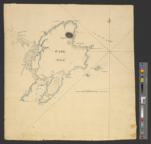
48
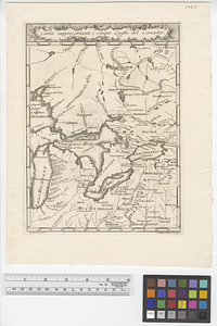
Creative Commons license
1
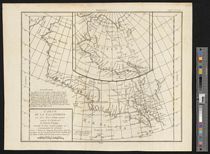
Search Constraints
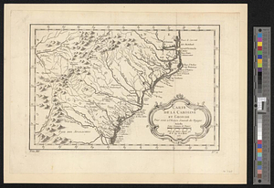
Sort by relevance
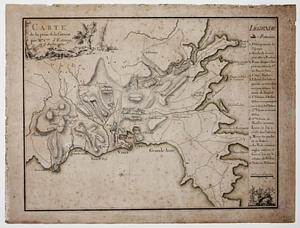
relevance
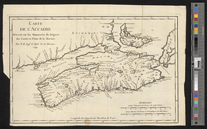
title
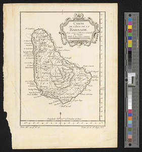
date (asc)
date (desc)
Number of results to display per page
20 per page
10
per page
20
per page
50
per page
100
per page
View results as:
grid view
map view
Search Results
121.
British capture of Savannah
122.
The British colonies in North America
123.
British dominions in America, drawn from the latest and best authorities
124.
British troop dispositions in and near New York City
125.
British troop dispositions in and near New York City, July and August 1781
126.
British troop dispositions in and near New York City, Sept. 2d 1781
127.
The British works at Yorktown and Gloucester
128.
Burlington, New Jersey, and Bristol, Pennsylvania
129.
Cambridge to Prospect Hill
130.
Campaign of Major General Anthony Wayne, 1793-94
131.
Canada
132.
Cantonment of the forces in N. America 1766
133.
Cape Ann
134.
Carta rappresentante i cinque laghi del Canada
135.
Carte composée des differens ouvrages de messieurs les ingenieurs qui ont eté à Louisiane, avec les renvois alphabetiques de...
136.
Carte de la Californie et des pays nord-ouest separés de l'Asie par le détroit d'Anian, extraite de deux cartes publiées au...
137.
Carte de la Caroline at Georgie pour servir à l'histoire générale des voyages : tirée des auteurs Anglois
138.
Carte de la prise de la Grenade par Mr. Cmte. d'Estaing, le 5 juillet 1779
139.
Carte de l'Accadie : dressée sur les manuscrits de Dépot des Cartes et Plans de la Marine
140.
Carte de l'isle de la Barbade pour servir à l'histoire générale des voyages
‹ Prev
Next ›
1
2
3
4
5
6
7
8
9
10
11
…
48
49