Toggle navigation
LMEC Home
Exhibitions
Georeferencing
Tools for Teachers
Collections
My Favorites
Sign Up / Log In
Search
Search the map portal
Map Collection
Map Collection
Map Sets
Search
Search
Search for
Search In
All Fields
Creator
Title
Subject
Place
Search All Digital Collections
Advanced Search
1291 Results
My Search
Start Over
More Like
commonwealth-oai:5m60vq35s
Remove constraint More Like: commonwealth-oai:5m60vq35s
Filter your Search
Place
North and Central America
1,232
United States
937
Canada
229
New York
193
Quebec
111
North America
86
Pennsylvania
61
New Jersey
54
more
Place
»
Topic
United States--Maps
330
United States--History--Revolution, 1775-1783--Maps
306
United States--History--French and Indian War, 1754-1763--Maps
151
North America--Maps
85
Saint Lawrence River--Maps
47
Elections--United States--Maps
36
Railroads--United States--Maps
34
Canada--Maps
31
more
Topic
»
Date
Date range begin
–
Date range end
Current results range from
1700
to
2023
View distribution
Creator
Paullin, Charles Oscar, 1868 or 1869-1944
70
Wright, John Kirtland, 1891-1969
70
Rocque, Mary Ann
29
Bellin, Jacques Nicolas, 1703-1772
27
Holland, Samuel, 1728-1801
25
Jefferys, Thomas, -1771
25
Montrésor, John, 1736-1799
25
Clinton, Henry, Sir, 1738?-1795
19
more
Creator
»
Format
Maps/Atlases
1,273
Drawings/Illustrations
11
Documents
5
Prints
3
Books
1
Manuscripts
1
Objects/Artifacts
1
Posters
1
Georeferenced
Yes
73
No
1,218
Collection
American Revolutionary War-Era Maps
972
William L. Clements Library Collection
909
Norman B. Leventhal Map & Education Center Collection
319
American Antiquarian Society Collection
37
MacLean Collection Map Library
15
New York Public Library Collection
10
David Judkins Weaver Papers
2
Mapping Boston Collection
2
more
Collection
»
Available to use
No known restrictions
244
Creative Commons license
16
Search Constraints
Sort by relevance
relevance
title
date (asc)
date (desc)
Number of results to display per page
20 per page
10
per page
20
per page
50
per page
100
per page
View results as:
grid view
map view
Search Results
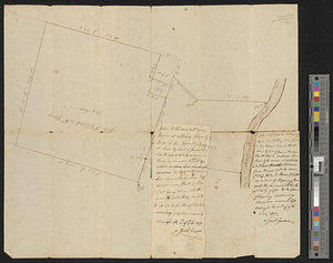
1101.
Plan resurvey'd for Jonathan Robinson all that his plantation by Raritan River containing 772 acres and the usual allowance for...
1102.
Plan. Road from Tatnic to Groundroothl
1103.
A plan shewing the situation & construction for a seat of government on the Mississippi
1104.
Plan von dem schiff-bauplatz bei Hallifax in Neuscholland
1105.
Plan von Fort Cumberland auf der insel St. Laurenti
1106.
Plan von Halifax in Nord-America
1107.
Plano de la costa de la Luciana decide el cabo de Loso hasta el cabo de San Blas sacado por los Yngs. el ano de 1769 con sur...
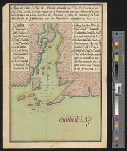
1108.
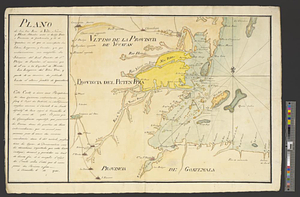
Plano de los Tres Rios de Valiz, Nuevo, y Hondo, situados entre et Golfo Dulce o provincia de Goatemala y de la Yucatan en et...
1109.
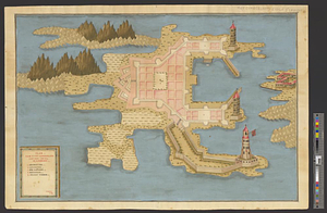
Plano de Puerto Rico
1110.
Plano del archipielago de Carrasco situado en la latd. N de 48 [degrees] 51', lond. 2 [degrees] al o. de sn. Blas reconocido el...
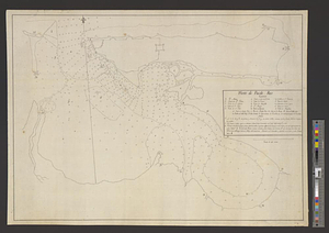
1111.
Plano del lago o rio de Movila situada su pta. en lt. N 30.10 en logd. 284.40 ms. Sacado se a consido consus nombres costas...
1112.
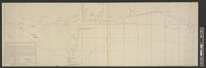
Plano del puerto de Floridablanca situado en la latd. N. de 54 [degrees] 16' longitud 28 [degrees] 15' al o de S. Blas...
1113.
Plano del puerto de Gaston situado en la latitude N de 53 [degrees] 28' longd 24 [degrees] 21 al o de S. Blas descubierto este ano
1114.
Plano del puerto de Panzacola en el qe. se manifiestan las marchas, campamentos y ataque de las tropas Espanolas : al mando del...
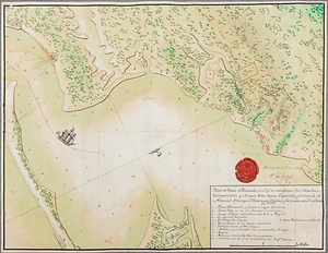
1115.
Plat of lands at Paulus Hook, New Jersey
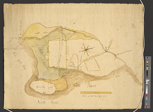
1116.
A plot of Wm Young's land including Delaware paper mill
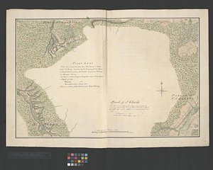
1117.
Point Levi. Parish of St. Charles
1118.
Portsmouth
1119.
Portsmouth and Norfolk
1120.
Position of the army near Iron Hill
‹ Prev
Next ›
1
2
…
52
53
54
55
56
57
58
59
60
…
64
65
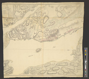
![Plano del archipielago de Carrasco situado en la latd. N de 48 [degrees] 51', lond. 2 [degrees] al o. de sn. Blas reconocido el los anos de 89 y 91](https://bpldcassets.blob.core.windows.net/derivatives/metadata/commonwealth-oai:8s45v8369/image_thumbnail_300.jpg)
![Plano del puerto de Floridablanca situado en la latd. N. de 54 [degrees] 16' longitud 28 [degrees] 15' al o de S. Blas descuvierto este ano](https://bpldcassets.blob.core.windows.net/derivatives/metadata/commonwealth-oai:2227rn003/image_thumbnail_300.jpg)
![Plano del puerto de Gaston situado en la latitude N de 53 [degrees] 28' longd 24 [degrees] 21 al o de S. Blas descubierto este ano](https://bpldcassets.blob.core.windows.net/derivatives/metadata/commonwealth-oai:c534kn51x/image_thumbnail_300.jpg)