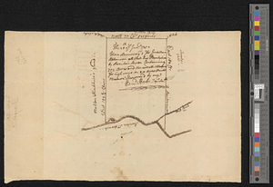
Plan resurvey'd for Jonathan Robinson all that his plantation by Raritan River containing 772 acres and the usual allowance for highways or 810 acres strickt
This map is also available in American Revolutionary Geographies Online (ARGO), a collections portal especially built for material relating to the American Revolutionary War Era. Visit ARGO to learn more about this item and explore the historical geography of North America in the late eighteenth century.
Item Information
- Title:
- Plan resurvey'd for Jonathan Robinson all that his plantation by Raritan River containing 772 acres and the usual allowance for highways or 810 acres strickt
- Creator:
- Beakes, Edmund
- Date:
-
[1779]
- Format:
-
Maps/Atlases
- Genre:
-
Manuscript maps
- Location:
- William L. Clements Library
- Collection (local):
-
William L. Clements Library Collection
- Subjects:
-
Real property--New Jersey--Hunterdon County--Maps
Hunterdon County (N.J.)--Maps
Raritan River (N.J.)--Maps
Robinson, Jonathan
- Places:
-
New JerseyHunterdon (county)
New JerseyRaritan (river)
- Extent:
- 1 ms. map ; 19.5 x 31 cm
- Terms of Use:
-
The University of Michigan Library provides access to these materials for educational and research purposes. These materials may be under copyright. If you decide to use any of these materials, you are responsible for making your own legal assessment and securing any necessary permission. If you have questions about the collection, please contact the William L. Clements Library.
Contact host institution for more information.
- Scale:
-
Scale [ca. 1:19,000].
- Language:
-
English
- Catalog Record:
-
Catalog record
- Notes:
-
Survey of land on the south branch of Raritan River in Hunterdon County, N.J.
- Notes (date):
-
This date is inferred.
- Identifier:
-
5508
- Barcode:
-
B1936459


