Toggle navigation
LMEC Home
Exhibitions
Georeferencing
Tools for Teachers
Collections
My Favorites
Sign Up / Log In
Search
Search the map portal
Map Collection
Map Collection
Map Sets
Search
Search
Search for
Search In
All Fields
Creator
Title
Subject
Place
Search All Digital Collections
Advanced Search
994 Results
My Search
Start Over
More Like
commonwealth-oai:5999s2744
Remove constraint More Like: commonwealth-oai:5999s2744
Filter your Search
Place
North and Central America
966
United States
705
Canada
205
New York
192
Quebec
111
Massachusetts
104
Boston Harbor
66
Pennsylvania
60
more
Place
»
Topic
United States--History--Revolution, 1775-1783--Maps
328
United States--History--French and Indian War, 1754-1763--Maps
149
Boston Harbor (Mass.)--Maps
67
Saint Lawrence River--Maps
43
Boston (Mass.)--Maps
30
Newport (R.I.)--Maps
27
New York (State)--Maps
24
Hudson River (N.Y. and N.J.)--Maps
21
more
Topic
»
Date
Date range begin
–
Date range end
Current results range from
1700
to
1985
View distribution
Creator
Rocque, Mary Ann
29
Holland, Samuel, 1728-1801
25
Montrésor, John, 1736-1799
25
Bellin, Jacques Nicolas, 1703-1772
24
Jefferys, Thomas, -1771
24
Clinton, Henry, Sir, 1738?-1795
19
Robert Sayer and John Bennett (Firm)
17
Hills, John, active 1777-1819
13
more
Creator
»
Format
Maps/Atlases
977
Drawings/Illustrations
11
Documents
5
Manuscripts
4
Prints
2
Posters
1
Georeferenced
Yes
10
No
984
Collection
American Revolutionary War-Era Maps
930
William L. Clements Library Collection
909
Norman B. Leventhal Map & Education Center Collection
65
Boston and New England Maps
60
Mapping Boston Collection
11
Urban Maps
11
Maritime Charts and Atlases
10
American Antiquarian Society Collection
8
more
Collection
»
Available to use
No known restrictions
58
Creative Commons license
16
Search Constraints
Sort by relevance
relevance
title
date (asc)
date (desc)
Number of results to display per page
20 per page
10
per page
20
per page
50
per page
100
per page
View results as:
grid view
map view
Search Results
641.
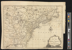
A new map of North America from the latest discoveries 1761
642.
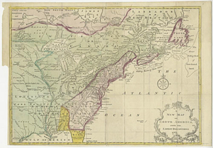
A new map of North America from the latest discoveries 1763
643.
A new map of the British dominions in North America with the limits of the governments annexed thereto by the late treaty of...
644.
A new map of the British empire in Nth. America, drawn from the latest authorities
645.
A new map of the Cherokee nation with the names of the towns & rivers : they are situated on no. lat. from 34 to 36
646.
A new map of the western parts of Virginia, Pennsylvania, Maryland and North Carolina; comprehending the river Ohio, and all...
647.
New Port
648.
North America
649.
North America
650.
North America east of the Mississippi, ca. 1790
651.
North America with the West India islands
652.
North Atlantic Ocean, ca. 1785
653.
A north view of Fort Franklin on French Creek
654.
Northeastern end of Long Island
655.
Nouvelle Angleterre, Nlle. York, Nlle. Jeersey, Pensilvanie, Mariland et Virginie
656.
La Nouvelle France ou Canada
657.
Nova orbis sive America Septentrionalis per sua regna provinc. et insul. cura et opera
658.
Oneida Lake to the Mohawk River
659.
The panorganon for solving the common problems of the terrestrial globe : Northern Hemisphere
660.
Parish of Batiscant. Parish of St. Pierre Becquet. Parish of Champlain. Parish of Gentilly
‹ Prev
Next ›
1
2
…
29
30
31
32
33
34
35
36
37
…
49
50