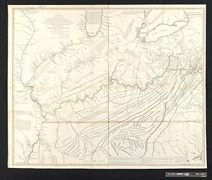
A new map of the western parts of Virginia, Pennsylvania, Maryland and North Carolina; comprehending the river Ohio, and all the rivers, which fall into it; part of the river Mississippi, the whole of the Illinois River, Lake Erie; part of the lakes Huron, Michigan &c. and all the country bordering on these lakes and rivers
This map is also available in American Revolutionary Geographies Online (ARGO), a collections portal especially built for material relating to the American Revolutionary War Era. Visit ARGO to learn more about this item and explore the historical geography of North America in the late eighteenth century.
Item Information
- Title:
- A new map of the western parts of Virginia, Pennsylvania, Maryland and North Carolina; comprehending the river Ohio, and all the rivers, which fall into it; part of the river Mississippi, the whole of the Illinois River, Lake Erie; part of the lakes Huron, Michigan &c. and all the country bordering on these lakes and rivers
- Contributor:
- Cheevers, J. (John)
- Creator:
- Hutchins, Thomas, 1730-1789
- Name on Item:
-
by Thos. Hutchins, captain in the 60th Regiment of Foot
- Date:
-
November 1, 1778
- Format:
-
Maps/Atlases
- Location:
- William L. Clements Library
- Collection (local):
-
William L. Clements Library Collection
- Subjects:
-
East (U.S.)--Maps
Canada, Eastern--Maps
Ohio River Valley--Maps
Mississippi River Valley--Maps
Northwest, Old--Maps
- Places:
-
Eastern United States (area)
Canada
Ohio River
Mississippi River
East North Central states (area)
- Extent:
- 1 map on 2 sheets : col. ; 93 x 111 cm
- Terms of Use:
-
The University of Michigan Library provides access to these materials for educational and research purposes. These materials may be under copyright. If you decide to use any of these materials, you are responsible for making your own legal assessment and securing any necessary permission. If you have questions about the collection, please contact the William L. Clements Library.
Contact host institution for more information.
- Publisher:
-
London :
T. Hutchins
- Scale:
-
Scale 1:1,250,000.
- Language:
-
English
- Catalog Record:
-
Catalog record
- Notes:
-
Engraved by: J. Cheevers.
Print annotations with comments on the country depicted.
- Identifier:
-
9131
- Barcode:
-
B1940746